IMAGES TAKEN NEAR TO
Elvet Close, NEWCASTLE UPON TYNE, NE13 7HE
Introduction
This page details the photographs taken nearby to Elvet Close, NE13 7HE by members of the Geograph project.
The Geograph project started in 2005 with the aim of publishing, organising and preserving representative images for every square kilometre of Great Britain, Ireland and the Isle of Man.

There are currently over 7.5m images from over14,400 individuals and you can help contribute to the project by visiting https://www.geograph.org.uk
Image Map
Images are licensed for reuse under creativecommons.org/licenses/by-sa/2.0
Notes
- Clicking on the map will re-center to the selected point.
- The higher the marker number, the further away the image location is from the centre of the postcode.
Image Listing (10 Images Found)
Images are licensed for reuse under creativecommons.org/licenses/by-sa/2.0
Image
Details
Distance
1
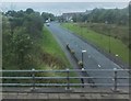
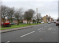
Darrell Street, Brunswick Village
Seen from a bridge on the A1.
Image: © Barbara Carr
Taken: 6 Sep 2013
0.02 miles
2
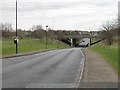
A1 passing Wideopen
Between Wideopen and Brunswick Village.
Image: © Richard Webb
Taken: 7 Mar 2009
0.04 miles
3
Wideopen : A1
Looking north along the A1.
Image: © Lewis Clarke
Taken: 21 Sep 2020
0.07 miles
4
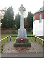
Brunswick Village War Memorial
The war memorial, which is a Grade II Listed Building, was erected in front of the Primary School on Darrell Street, where it was unveiled on 12 March 1921. It commemorates 52 local servicemen who died during the First World War, and three who fell in the Second World War. The memorial was subsequently moved to is current position on the opposite side of the road, close to the east end of St Cuthbert’s Mission Church.
Image: © Geoff Holland
Taken: 10 Nov 2020
0.08 miles
5
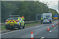
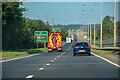
Wideopen : A1
A breakdown on the A1 caused delays.
Image: © Lewis Clarke
Taken: 25 Sep 2020
0.08 miles
6

Wideopen : A1
Traffic officers on the A1.
Image: © Lewis Clarke
Taken: 25 Sep 2020
0.10 miles
7
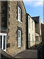
Darrell House, Darrell Street, Brunswick Village
At the time of the publication of the 1921 edition of the Ordnance Survey Six-Inch map of the area the village of Brunswick, as such, did not exist. The area where the village now stands was occupied by Dinnington Colliery and numerous rows of miners dwellings. This property was part of the colliery. The first deep mine at the site was sunk in 1867. At its peak the colliery employed over 1000 people, but closed in February 1960.The village was initially known as Dinnington Colliery, but its name was later changed to Brunswick. The village is half in the Metropolitan Borough of North Tyneside and half in the Metropolitan Borough of Newcastle upon Tyne.
Image: © Geoff Holland
Taken: 10 Nov 2020
0.11 miles
8
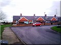
Aged Miners Homes, Brunswick Village
These terraced bungalows are typical of those in many ex-mining villages in the North East. Originally built for retired miners, many have now been sold off. These ones were in a quiet spot originally, but now have the A1 motorway not far from the bottom of their gardens.
Image: © Robert Graham
Taken: 28 Nov 2011
0.17 miles
9
Brunswick Village
About six mile north of Newcastle upon Tyne.
Image: © Chris Tweedy
Taken: 19 Jan 2006
0.19 miles
10
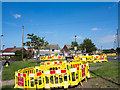
Excavations on Stalks Road
Northern Gas is responsible for these excavations on Stalks Road, Wideopen; there are signs apologising for any convenience.
Image: © Trevor Littlewood
Taken: 30 Jun 2015
0.20 miles