IMAGES TAKEN NEAR TO
Linnet Close, NEWCASTLE UPON TYNE, NE13 6NR
Introduction
This page details the photographs taken nearby to Linnet Close, NE13 6NR by members of the Geograph project.
The Geograph project started in 2005 with the aim of publishing, organising and preserving representative images for every square kilometre of Great Britain, Ireland and the Isle of Man.

There are currently over 7.5m images from over14,400 individuals and you can help contribute to the project by visiting https://www.geograph.org.uk
Image Map
Images are licensed for reuse under creativecommons.org/licenses/by-sa/2.0
Notes
- Clicking on the map will re-center to the selected point.
- The higher the marker number, the further away the image location is from the centre of the postcode.
Image Listing (23 Images Found)
Images are licensed for reuse under creativecommons.org/licenses/by-sa/2.0
Image
Details
Distance
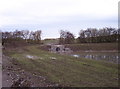
1
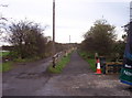
Disused Wagonway
Looking east along an old wagonway which has been reclaimed for use as a public footpath.
Image: © Weston Beggard
Taken: 5 Nov 2005
0.05 miles
2
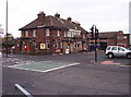
Travellers Rest
A large, food-oriented pub in a busy residential area.
Image: © Weston Beggard
Taken: 5 Nov 2005
0.05 miles
3
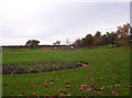
Lockey Park
A public park with kids' play area in Wideopen.
Image: © Weston Beggard
Taken: 5 Nov 2005
0.05 miles
4
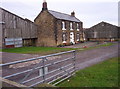
East Wideopen Farm
Farm buildings at East Wideopen
Image: © Weston Beggard
Taken: 5 Nov 2005
0.05 miles
5
Drainage
Much of the land round East Wideopen is peppered with modern field drainage like this.
Image: © Weston Beggard
Taken: 5 Nov 2005
0.05 miles
6

Railway Bridge
Looking south under an old railway bridge which now carries a public footpath.
Image: © Weston Beggard
Taken: 5 Nov 2005
0.05 miles
7

Bridge on Disused Wagonway
View looking west along a disused wagonway which runs eastwards from Wideopen.
Image: © Weston Beggard
Taken: 5 Nov 2005
0.05 miles
8
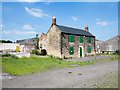
Boarded farmhouse at East Wideopen
East Wideopen is a farm lying just to the east of Wideopen. The house is boarded and the buildings fenced around for security but the property is apparently in good order (June 2015) and not abandoned.
Image: © Trevor Littlewood
Taken: 30 Jun 2015
0.07 miles
9
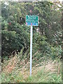
Sign, East Wideopen
This sign stands at the junction of two public bridleways, one which forms part of the Reivers Cycle Route, and the other which leads to nearby Lockey Park and the Great North Road in Wideopen. Behind the trees lies a new housing estate which stands on the site of the old East Wideopen Farm. For a selection of detailed free to download walking routes in the area visit www.northtynesidewalks.co.uk
Image: © Geoff Holland
Taken: 5 Aug 2020
0.10 miles
10
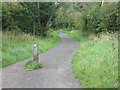
Public Bridleway, Wideopen
This public bridleway forms part of the Reivers Route, a 170-mile coast-to-coast cycle route from Tynemouth to Whitehaven which passes through unspoilt Northumberland, the Kielder Forest, Carlisle and the Lake District. At this point it is following the course of the former Seatonburn Waggonway. For a selection of detailed free to download walking routes in the area visit www.northtynesidewalks.co.uk
Image: © Geoff Holland
Taken: 5 Aug 2020
0.11 miles