IMAGES TAKEN NEAR TO
West Farm Avenue, NEWCASTLE UPON TYNE, NE12 8RS
Introduction
This page details the photographs taken nearby to West Farm Avenue, NE12 8RS by members of the Geograph project.
The Geograph project started in 2005 with the aim of publishing, organising and preserving representative images for every square kilometre of Great Britain, Ireland and the Isle of Man.

There are currently over 7.5m images from over14,400 individuals and you can help contribute to the project by visiting https://www.geograph.org.uk
Image Map
Images are licensed for reuse under creativecommons.org/licenses/by-sa/2.0
Notes
- Clicking on the map will re-center to the selected point.
- The higher the marker number, the further away the image location is from the centre of the postcode.
Image Listing (17 Images Found)
Images are licensed for reuse under creativecommons.org/licenses/by-sa/2.0
Image
Details
Distance
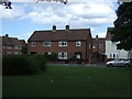
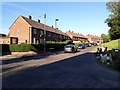
1
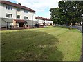
Flats, West Farm Avenue, Longbenton
Blocks of flats on the southern side of West Farm Avenue in Longbenton.
Image: © Graham Robson
Taken: 10 Jul 2020
0.06 miles
2
Houses, Oxford Close, Longbenton
Houses and flats with their main accesses on Oxford Close facing out on Benton Lane.
Image: © Graham Robson
Taken: 10 Jul 2020
0.08 miles
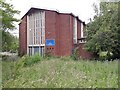
3
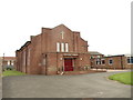
Longbenton Methodist Church, Chesters Avenue, Longbenton
Image: © Bill Henderson
Taken: 11 Jun 2012
0.08 miles
4
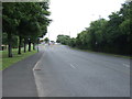
Benton Lane (A188)
Heading south towards Newcastle.
Image: © JThomas
Taken: 3 Aug 2013
0.13 miles
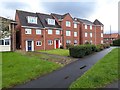
6
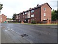
Flats, West Farm Avenue, Longbenton
A block of flats on the southern side of West Farm Avenue in Longbenton.
Image: © Graham Robson
Taken: 10 Jul 2020
0.14 miles
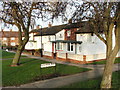
7
Charnwood Avenue, Longbenton
A residential street in Longbenton. There are modern semi-detached houses on the road's western side.
Image: © Graham Robson
Taken: 22 Jun 2020
0.16 miles
8
Houses
These charming houses are just off the main A191 road and opposite the ever expanding site of the DWP.
Image: © Christine Westerback
Taken: 30 Jan 2006
0.19 miles
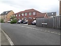
9
Whitby Crescent, Longbenton
Terraced houses in Longbenton close to the Four Lane Ends public transport interchange.
Image: © Graham Robson
Taken: 1 Jun 2020
0.20 miles
10
Former Catholic church, Benton Lane, Longbenton
The front of the former St Peter and St Paul's Catholic Church on Benton Lane. The building's doors have been boarded up, several windows have been smashed and the grounds are overgrown.
Image: © Graham Robson
Taken: 29 Jun 2020
0.21 miles