IMAGES TAKEN NEAR TO
Castle Garth, NEWCASTLE UPON TYNE, NE1 1RQ
Introduction
This page details the photographs taken nearby to Castle Garth, NE1 1RQ by members of the Geograph project.
The Geograph project started in 2005 with the aim of publishing, organising and preserving representative images for every square kilometre of Great Britain, Ireland and the Isle of Man.

There are currently over 7.5m images from over14,400 individuals and you can help contribute to the project by visiting https://www.geograph.org.uk
Image Map
Images are licensed for reuse under creativecommons.org/licenses/by-sa/2.0
Notes
- Clicking on the map will re-center to the selected point.
- The higher the marker number, the further away the image location is from the centre of the postcode.
Image Listing (2574 Images Found)
Images are licensed for reuse under creativecommons.org/licenses/by-sa/2.0
Image
Details
Distance
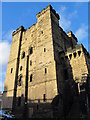
1
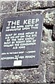
Newcastle Royal Keep
Entrance price in old money - Admission 2/- [Two shillings] per person! Sign reads 'The Keep of the Royal Castle of Newcastle upon Tyne. Built by King Henry II 1133-1189AD, on the site of the "New Castle" built by Robert son of William the Conqueror AD1080".
Image: © Stanley Howe
Taken: Unknown
0.00 miles
2
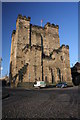
The Castle Keep
Built by Henry II between 1168 and 1178.
Image: © Peter McDermott
Taken: 6 Jan 2008
0.00 miles
3
Castle Keep, Newcastle Upon Tyne
Castle Keep built between 1172 and 1177.The Keep is a Grade I listed building, and a Scheduled Ancient Monument.
https://en.wikipedia.org/wiki/The_Castle,_Newcastle
Image: © Brian Deegan
Taken: 13 Sep 2021
0.00 miles
4
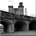
Railway arches and Newcastle Castle seen from near The Black Gate
Image: © habiloid
Taken: 30 May 2022
0.00 miles
5
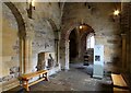
The Chapel
I am in the Castle Keep, Newcastle-upon-Tyne and this is the chapel with its beautifully rendered zig-zag patterned Norman archways. This hhapel would probably have been the preserve of royalty, garrison officers and important visitors.
Image: © Carroll Pierce
Taken: 7 Sep 2023
0.00 miles
6
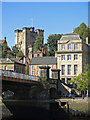
(Part of) the Swing Bridge, Sandhill, and the Keep
After all the bridges on the Tyne, except for the Image (photographed by Dennis Lovett), were destroyed in the great flood of 1771, a 9-arch stone bridge was built on this site. This bridge was removed by the River Tyne Improvement Commission in the late 1860s, because large vessels were unable to pass beneath its arches, and the Swing Bridge built in its place. The stone abutment (centre) is a relic of the Georgian bridge https://www.portoftyne.co.uk/about-us/history/heritage-sites/heritage-sites .
Image: © Mike Quinn
Taken: 21 Sep 2019
0.00 miles
7
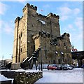
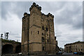
Castle Keep, Newcastle
The Keep on Castle Garth dates from C12 to C13. Many of the walls of the castle were lost when the railway viaduct was built between the Keep and the Black Gate Image These are visible behind. Views from the roof of the tower can be superb Image
Image: © Andrew Curtis
Taken: 7 Jan 2010
0.01 miles
8
Benchmark on Castle
Honestly, the Ordnance Survey have no respect for our heritage! And that stonework looks a bit dodgy, too. 28.72 above OSDN.
Image: © Keith Edkins
Taken: 11 Mar 2012
0.01 miles
10
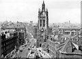
Newcastle-on-Tyne, 1960: St Nicholas Street and Church from Castle Keep
View NW.
Image: © Ben Brooksbank
Taken: 12 Aug 1960
0.01 miles