IMAGES TAKEN NEAR TO
Haswell Close, GATESHEAD, NE10 8UE
Introduction
This page details the photographs taken nearby to Haswell Close, NE10 8UE by members of the Geograph project.
The Geograph project started in 2005 with the aim of publishing, organising and preserving representative images for every square kilometre of Great Britain, Ireland and the Isle of Man.

There are currently over 7.5m images from over14,400 individuals and you can help contribute to the project by visiting https://www.geograph.org.uk
Image Map
Images are licensed for reuse under creativecommons.org/licenses/by-sa/2.0
Notes
- Clicking on the map will re-center to the selected point.
- The higher the marker number, the further away the image location is from the centre of the postcode.
Image Listing (15 Images Found)
Images are licensed for reuse under creativecommons.org/licenses/by-sa/2.0
Image
Details
Distance
2
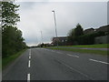
Sherburn Way
Entrance to a housing estate off Leam Lane (B1288).
Image: © JThomas
Taken: 18 Aug 2018
0.09 miles
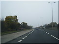
3
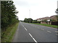
The B1288 on the line of Wrakendyke Roman Road
Image: © Peter Robinson
Taken: 6 May 2012
0.11 miles
4
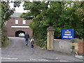
Wardley Legion Club
A traditional club just off Sunderland Road. Children welcome.
Image: © MSX
Taken: 15 Oct 2005
0.15 miles

6
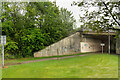
Cyclepath and Felling Bypass Subway
The underpass below the A184, Felling Bypass. The path follows part of the old Bowes Railway, originally a colliery railway built to carry coal from the pits at Dipton to the Tyne at Jarrow. The line closed in 1974 and The path following its route is now designated as Regional Route 11 of the National Cycle Network.
Image: © David Dixon
Taken: 21 May 2021
0.17 miles
7
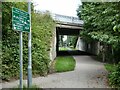
Bowes Railway Path passing under Felling Bypass (A184)
The Bowes Railway was an old colliery railway which ran from Andrews House, Sunniside to coal staithes at Jarrow. Most of the length of the line has now been converted to a cycle path, designated Regional Route 11 of the National Cycle Network.
Image: © Oliver Dixon
Taken: 14 Jul 2021
0.17 miles
9
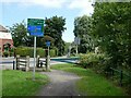
Crossing of Bowes Railway Path over Sunderland Road (A195)
The Bowes Railway was an old colliery railway which ran from Andrews House, Sunniside to coal staithes at Jarrow. Most of the length of the line has now been converted to a cycle path, designated Regional Route 11 of the National Cycle Network.
Image: © Oliver Dixon
Taken: 14 Jul 2021
0.18 miles
10
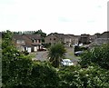
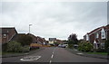
Houses in Clanton Close
Seen from the Bowes Railway Path.
Image: © Oliver Dixon
Taken: 14 Jul 2021
0.18 miles