IMAGES TAKEN NEAR TO
Longrigg, GATESHEAD, NE10 8PJ
Introduction
This page details the photographs taken nearby to Longrigg, NE10 8PJ by members of the Geograph project.
The Geograph project started in 2005 with the aim of publishing, organising and preserving representative images for every square kilometre of Great Britain, Ireland and the Isle of Man.

There are currently over 7.5m images from over14,400 individuals and you can help contribute to the project by visiting https://www.geograph.org.uk
Image Map (Loading...)


Getting Data...Please wait
Leaflet Map data © OpenStreetMap
Images are licensed for reuse under creativecommons.org/licenses/by-sa/2.0
Notes
- Clicking on the map will re-center to the selected point.
- The higher the marker number, the further away the image location is from the centre of the postcode.
Image Listing (18 Images Found)
Images are licensed for reuse under creativecommons.org/licenses/by-sa/2.0
Image
Details
Distance
1
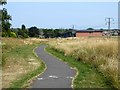
Cycleway above Heworth Leisure Centre
The cycleway follows the line of an old railway.
Image: © Oliver Dixon
Taken: 26 Jul 2018
0.10 miles
2
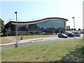
Heworth Leisure Centre
One of a number of leisure centres operated by GO Gateshead.
Image: © Oliver Dixon
Taken: 26 Jul 2018
0.11 miles
3
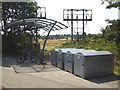
Cycle racks and lockers at Heworth Leisure Centre
Image: © Oliver Dixon
Taken: 26 Jul 2018
0.14 miles
4
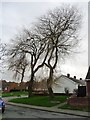
Trees at the northern end of Bleachfeld
Just a hint of green at the end of February.
Image: © Christine Johnstone
Taken: 25 Feb 2017
0.14 miles
5
Former railway bridges over Colegate West
The nearer [eastern] one is on the route of the Upper Heworth wagonway. The far on is on the route of the Ouston & Pelaw wagonway.
Image: © Christine Johnstone
Taken: 25 Feb 2017
0.14 miles
6
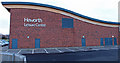
Heworth Leisure Centre
View of the rear of building.
Image: © wfmillar
Taken: 3 Jan 2014
0.15 miles
7
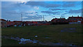
Heworth
Bit of unused ground beside the leisure Ctr. looking towards High Lanes road.
Image: © wfmillar
Taken: 3 Jan 2014
0.16 miles
8
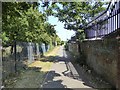
Cycleway in High Heworth
Following an old railway line, this length of cycleway is signed as "East Gateshead Cycleway" at the south-west end, but as "The Angel Cycleway" at the north-east end.
Image: © Oliver Dixon
Taken: 26 Jul 2018
0.17 miles
9
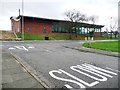
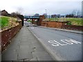
Slow at the junction of Laburnum Avenue and High Lanes
Opposite Heworth Leisure Centre.
Image: © Christine Johnstone
Taken: 25 Feb 2017
0.18 miles
10
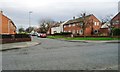
Houses on the south side of Bolburn, off Grange Crescent
Many of the roads round here have single-word archaic names.
Image: © Christine Johnstone
Taken: 25 Feb 2017
0.19 miles