IMAGES TAKEN NEAR TO
Lauder Way, GATESHEAD, NE10 0BG
Introduction
This page details the photographs taken nearby to Lauder Way, NE10 0BG by members of the Geograph project.
The Geograph project started in 2005 with the aim of publishing, organising and preserving representative images for every square kilometre of Great Britain, Ireland and the Isle of Man.

There are currently over 7.5m images from over14,400 individuals and you can help contribute to the project by visiting https://www.geograph.org.uk
Image Map
Images are licensed for reuse under creativecommons.org/licenses/by-sa/2.0
Notes
- Clicking on the map will re-center to the selected point.
- The higher the marker number, the further away the image location is from the centre of the postcode.
Image Listing (143 Images Found)
Images are licensed for reuse under creativecommons.org/licenses/by-sa/2.0
Image
Details
Distance
2
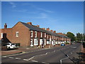
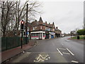
Shields Road, Pelaw, near Gateshead
Shields Road passing through Pelaw. This road forms part of the route of the A185.
Image: © Malc McDonald
Taken: 20 Sep 2019
0.04 miles
3
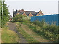
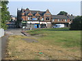
Former Railway Bridge
This hump in the path is a filled in footbridge. Beyond is the old Co-Op building.
Image: © MSX
Taken: 25 Jul 2006
0.08 miles
4
Station Road From Footbridge
The path of the old Dilly Lines leads on to Station Road and Bill Quay.
Image: © MSX
Taken: 25 Jul 2006
0.09 miles
5
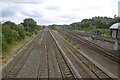
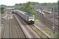
Railway, Pelaw
Both Metro and mainline rail services use tracks here, Metro on the right. This is just east of Pelaw Station. A Grand Central train used the weedy track in the centre. This company serves Sunderland from the South, so presumably was empty.
Image: © Richard Webb
Taken: 9 Aug 2016
0.09 miles
6
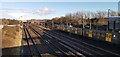
Metro train for South Shields at Pelaw
With stabling sidings where units are held for use on all routes when service needs arise.
Image: © Chris Morgan
Taken: 20 Feb 2020
0.10 miles
7
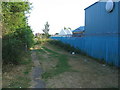
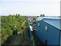
Edge Of Stonehills
Perimeter of Stonehills Industrial Estate following the path of an old goods railway.
Image: © MSX
Taken: 25 Jul 2006
0.11 miles
9
Newcastle to Sunderland railway, Pelaw
Metro tracks on the right. The Grand Central HST is probably out of service - they run a service to Sunderland from London, King's Cross.
Image: © Richard Webb
Taken: 9 Aug 2016
0.11 miles
10
Shields Road / Station Road Junction
At junction lies the old Co-Op building.
Image: © MSX
Taken: 25 Jul 2006
0.11 miles