IMAGES TAKEN NEAR TO
Highbank Way, LONDON, N8 9NZ
Introduction
This page details the photographs taken nearby to Highbank Way, N8 9NZ by members of the Geograph project.
The Geograph project started in 2005 with the aim of publishing, organising and preserving representative images for every square kilometre of Great Britain, Ireland and the Isle of Man.

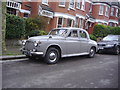
There are currently over 7.5m images from over14,400 individuals and you can help contribute to the project by visiting https://www.geograph.org.uk
Image Map
Images are licensed for reuse under creativecommons.org/licenses/by-sa/2.0
Notes
- Clicking on the map will re-center to the selected point.
- The higher the marker number, the further away the image location is from the centre of the postcode.
Image Listing (141 Images Found)
Images are licensed for reuse under creativecommons.org/licenses/by-sa/2.0
Image
Details
Distance
1
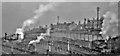
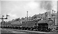
Panorama of Ferme Park Yards from near Harringay station
The footbridge that gave access to Harringay (West) station continued west and north to a vista above the great Ferme Park Yards towards Hornsey. Here we have a view NE, with one ex-GN J52 0-6-0ST on a train coming over the flyover from the Down Yard and probably assisted in the rear, while another J52 waits with a train from the Up Yard. The main lines are partly visible bottom left. [Apologies for the quality, but I caught the atmosphere].
Image: © Ben Brooksbank
Taken: 8 Nov 1947
0.02 miles
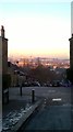
2
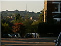
Ridge Road
Stationers Park is to the left off Denton Road, down the hill in this view.
Image: © Peter S
Taken: 26 Sep 2009
0.07 miles
3
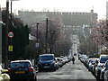
Chettle Court London N8
Looking west down Roseberry Gardens, across Green Lanes and up Duckett Road (which crosses over the New River) the eye first meets the block of flats, "Milverton", on Wightman Road. Looming above that is Chettle Court, a large 1960's Council housing development that stands on the edge of a deep cutting in which runs the Kings Cross to Edinburgh main railway line. Within the space of half a mile that's two roads, one man made river and a railway all heading north- south through Haringey.
Image: © John Kingdon
Taken: 18 Feb 2024
0.07 miles
4
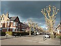
NEW
Mount View Road N4
Looking east on a clear cold spring day the sun highlights the pollarded trees against a darkening sky. I always read faces and bodies into the gnarled boughs as if some ancient Greek myth was coming to life in north London.
Image: © John Kingdon
Taken: 12 Mar 2025
0.09 miles
5
Old Rover car on Stapleton Hall Road, Harringay
Image: © David Howard
Taken: 2 Apr 2008
0.09 miles
6
Ally Pally from Oakfield Road N4
Looking down the north facing slope of Oakfield Road across Ridge Road and down Denton Road. The winter sun catches Alexandra Palace on the opposite south facing slope.
Image: © John Kingdon
Taken: 12 Dec 2017
0.09 miles
7
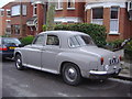
Old Rover P4 car on Stapleton Hall Road, Harringay
I always take old cars when I see them, you can see by the rust on this they don't last forever.
Image: © David Howard
Taken: 2 Apr 2008
0.09 miles
9
Up freight at Harringay West, with ex-WD 0-6-0T
Leaving Ferme Park Up Yard, probably for New Cross Gate (SR) via Blackfriars Bridge and London Bridge (see single lamp in the centre of the buffer-beam), the train is headed by one of the ex-WD 0-6-0ST acquired by the LNER (see Image]), No. 68077 was built in 1/47 as WD No. 71466 and withdrawn in 12/62 but was preserved and acquired by the heritage Spa Valley Railway.
Image: © Ben Brooksbank
Taken: 2 Jun 1959
0.10 miles
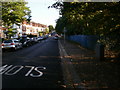
10
View across Harringay from Quernmore Road
Image: © David Howard
Taken: 2 Apr 2008
0.11 miles