IMAGES TAKEN NEAR TO
Crouch End Hill, LONDON, N8 8DE
Introduction
This page details the photographs taken nearby to Crouch End Hill, N8 8DE by members of the Geograph project.
The Geograph project started in 2005 with the aim of publishing, organising and preserving representative images for every square kilometre of Great Britain, Ireland and the Isle of Man.

There are currently over 7.5m images from over14,400 individuals and you can help contribute to the project by visiting https://www.geograph.org.uk
Image Map
Images are licensed for reuse under creativecommons.org/licenses/by-sa/2.0
Notes
- Clicking on the map will re-center to the selected point.
- The higher the marker number, the further away the image location is from the centre of the postcode.
Image Listing (223 Images Found)
Images are licensed for reuse under creativecommons.org/licenses/by-sa/2.0
Image
Details
Distance
1
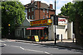
Crescent Cafe
Located next to the closed Crouch End station. I believe that this cafe and the adjacent shop may have been a newsagents and coal merchants office back in the days when the line was open, but further investigation is required.
Image: © Martin Addison
Taken: 22 May 2009
0.01 miles
2
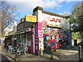
Would have been the Station Cafe
A lot of stations have cafes by the entrance to serve a brew to thirsty commuters, and I'm guessing Crouch End station was no different in its day.
This is at the top of the steps leading down to the platforms of the long abandoned station which saw its last passengers back in 1954.
Unlike the station, the cafe is still in business. Covered in graffiti like the old bridge and station remnants below, the cafe looks to have gone along with the bright colours of the artists.
If you can't beat them, join them.
Image: © Des Blenkinsopp
Taken: 2 Feb 2016
0.02 miles
3
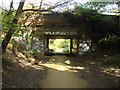
Bridge carrying Crouch End Hill over former railway route
Located on Parkland Walk a 4.5-mile (7.2 km) linear green walkway which was a former Great Northern Railway line. The platforms of the former Crouch End station can be seen just beyond the bridge.
Image: © Oxyman
Taken: 22 Apr 2009
0.02 miles
4
Looking up at the Crouch End Hill bridge from the Parkland Walk
Looking northeast.
Image: © Robert Lamb
Taken: 21 Sep 2019
0.02 miles
5
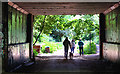
Walking The Dog
Pedestrians pass under Crouch End Hill as they walk along the Parkland Walk, part of the Capital Ring of footpaths. This is part of the dismantled Finsbury Park to Highgate section of the Northern Heights branch. Visible through the arch are the platforms of the one-time Crouch End station.
Image: © Martin Addison
Taken: 22 May 2009
0.03 miles
6
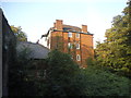
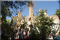
Block of flats on Crouch End Hill
One of the old stations disused since the 1950s is on the left, Crouch End.
Image: © David Howard
Taken: 9 Sep 2014
0.03 miles
7
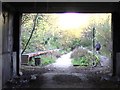
Crouch End Hill Station on Parkland Walk
These are the station platforms viewed through the arch of Crouch End Hill bridge. The single track steam railway ran from Finsbury Park Station to Alexandra Palace via Highgate and was closed in the 1950s. The section of the railway route from Highgate to Finsbury Park is now a nature reserve named Parkland Walk and is part of the Capital Ring.
Image: © Peter Neal
Taken: 27 Nov 2009
0.03 miles
8
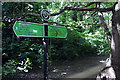
Capital Ring Signpost
Giving distances to various points along the way. The furthest listed being Woolwich Foot Tunnel to the left at sixteen and a half miles and Richmond Bridge to the right at twenty-six and a half miles.
Image: © Martin Addison
Taken: 22 May 2009
0.03 miles
9
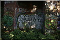
View of graffiti on the former Crouch End station wall on the Parkland Walk #11
Looking northeast.
Image: © Robert Lamb
Taken: 21 Sep 2019
0.03 miles
10
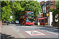
Crouch End Hill
DLA280 reaches the summit of the climb from Crouch End. It's all downhill now to Archway on the 41 bus route. This is the site of Crouch End station on the Finsbury Park to High Barnet and Alexandra Palace railway line.
Image: © Martin Addison
Taken: 22 May 2009
0.03 miles