IMAGES TAKEN NEAR TO
Crescent Road, LONDON, N8 8AZ
Introduction
This page details the photographs taken nearby to Crescent Road, N8 8AZ by members of the Geograph project.
The Geograph project started in 2005 with the aim of publishing, organising and preserving representative images for every square kilometre of Great Britain, Ireland and the Isle of Man.

There are currently over 7.5m images from over14,400 individuals and you can help contribute to the project by visiting https://www.geograph.org.uk
Image Map
Images are licensed for reuse under creativecommons.org/licenses/by-sa/2.0
Notes
- Clicking on the map will re-center to the selected point.
- The higher the marker number, the further away the image location is from the centre of the postcode.
Image Listing (186 Images Found)
Images are licensed for reuse under creativecommons.org/licenses/by-sa/2.0
Image
Details
Distance
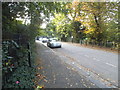
4
Crescent Road looking towards Crouch End Hill
Technically this is no longer a road junction, but being a crescent you turn left before taking this part and catch the main road a little further along to the left.
Image: © David Howard
Taken: 9 Sep 2014
0.05 miles
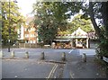
5
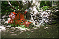
Tree and Bricks
Beside the Parkland Walk, near to the site of Crouch End Station on the dismantled Finsbury Park to highgate section of the Northern Heights branch. The red paint cannot hide the fact that the bricks are of the yellow type favoured by the Great Northern Railway for its buildings and are probably the remains of a signal box that existed here to control a crossover and access to a siding for coal wagons. The box closed in 1932 after colour light signalling was installed along the line.
Image: © Martin Addison
Taken: 22 May 2009
0.06 miles
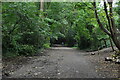
6
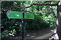
Parkland Walk near Crouch End
This section of the Parkland Walk is also on the route of the Capital Ring. The signpost to the left indicates the route of the Capital Ring.
Image: © Malc McDonald
Taken: 13 Aug 2023
0.06 miles
8
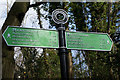
Capital Ring Signpost
Giving distances to various points along the way. The furthest listed being Woolwich Foot Tunnel to the left at sixteen and a half miles and Richmond Bridge to the right at twenty-six and a half miles.
Image: © Martin Addison
Taken: 22 May 2009
0.06 miles
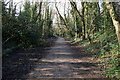
9
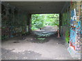
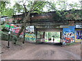
Crouch End: Former railway line
This is the trackbed of the former Great Northern Railway line from Finsbury Park to Alexandra Palace via Highgate, as viewed looking west under the Crouch End Hill road bridge, from the site of the former Crouch End railway station. The track was lifted in 1972, some 18 years after the station closed. The trackbed is now a public footpath called Parkland Walk and the whole of the former railway property is the Railway Fields Local Nature Reserve.
Image: © Nigel Cox
Taken: 20 Jun 2007
0.06 miles
10
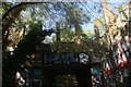
View of the Crouch End Hill bridge on the Parkland Walk
Looking northwest.
Image: © Robert Lamb
Taken: 21 Sep 2019
0.07 miles