IMAGES TAKEN NEAR TO
Alexandra Road, LONDON, N8 0PL
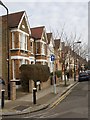
Introduction
This page details the photographs taken nearby to Alexandra Road, N8 0PL by members of the Geograph project.
The Geograph project started in 2005 with the aim of publishing, organising and preserving representative images for every square kilometre of Great Britain, Ireland and the Isle of Man.

There are currently over 7.5m images from over14,400 individuals and you can help contribute to the project by visiting https://www.geograph.org.uk
Image Map
Images are licensed for reuse under creativecommons.org/licenses/by-sa/2.0
Notes
- Clicking on the map will re-center to the selected point.
- The higher the marker number, the further away the image location is from the centre of the postcode.
Image Listing (220 Images Found)
Images are licensed for reuse under creativecommons.org/licenses/by-sa/2.0
Image
Details
Distance
1
Burghley Road "PlaySpace"
A community centre for the under fives. I have been unable to find out much about its previous history and would welcome elucidation. It was first opened in 1897, possibly as a school?
Image: © Neil Theasby
Taken: 7 Oct 2018
0.05 miles
2
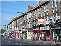
Burghley Road, N8
Picture taken from Turnpike Lane.
Image: © Danny P Robinson
Taken: 13 Jan 2008
0.06 miles
3
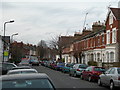
Wet afternoon on Turnpike Lane
Along the north side of Turnpike Lane here, the left side of the picture, shops and workshops have been built onto what used to be the gardens of Victorian houses behind.
Image: © Christopher Hilton
Taken: 21 Sep 2015
0.09 miles
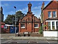
4
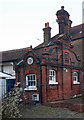
Burghley Road Under 5's Community Centre
Built as a sewage pumping station, dated 1897. A designated site of industrial heritage interest.
Image: © Jim Osley
Taken: 27 Dec 2013
0.09 miles
5
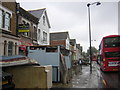
Wet afternoon on Turnpike Lane
Along the north side of Turnpike Lane here, the left side of the picture, shops and workshops have been built onto what used to be the gardens of Victorian houses behind.
Image: © Christopher Hilton
Taken: 21 Sep 2015
0.09 miles
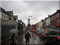
8
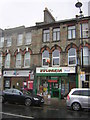
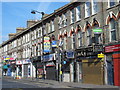
Shops on Turnpike Lane
A shop selling Bulgarian foods sits next to an office offering assistance with visa applications: an indication of the area's large proportion of relatively-recent immigrants to the United Kingdom.
Image: © Christopher Hilton
Taken: 21 Sep 2015
0.10 miles
9
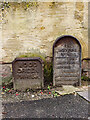
Hornsey Parish boundary marker no. 19 (1887)
Image: © Jim Osley
Taken: 17 Nov 2020
0.10 miles