IMAGES TAKEN NEAR TO
Allison Road, LONDON, N8 0AP
Introduction
This page details the photographs taken nearby to Allison Road, N8 0AP by members of the Geograph project.
The Geograph project started in 2005 with the aim of publishing, organising and preserving representative images for every square kilometre of Great Britain, Ireland and the Isle of Man.

There are currently over 7.5m images from over14,400 individuals and you can help contribute to the project by visiting https://www.geograph.org.uk
Image Map
Images are licensed for reuse under creativecommons.org/licenses/by-sa/2.0
Notes
- Clicking on the map will re-center to the selected point.
- The higher the marker number, the further away the image location is from the centre of the postcode.
Image Listing (133 Images Found)
Images are licensed for reuse under creativecommons.org/licenses/by-sa/2.0
Image
Details
Distance
1

Allison Road
One of the streets built circa 1880 and forming the Harringay Park area between Green Lanes and the Great Northern mainline. These streets are also referred to as the Harringay Ladder because of the regular ground plan.
Image: © Martin Addison
Taken: 12 Feb 2013
0.05 miles
2
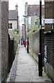
Harringay Passage
A narrow footpath running roughly north-south through the centre of the streets forming the Harringay Ladder. The pronounced slope of the land is evident from the angle of the paving slabs in relation to the walls of the buildings.
Image: © Martin Addison
Taken: 12 Feb 2013
0.05 miles
5
Hewitt Road looking towards Green Lanes
The building visible on Green Lanes is Salisbury Parade and now houses a Tesco Express at street level. In time gone by the upstairs housed Bolts, a gay nightclub made famous by George Michael. For the few decades, the upstairs premises was home to the Salon du Bal, linked to the adjacent Coliseum cinema (now demolished).
Image: © hjuk
Taken: 5 Jun 2007
0.06 miles
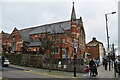
6
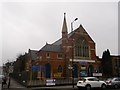
Harringay United Baptist Church
On the junction of Green Lanes and Allison Road (on the left).
Image: © David Anstiss
Taken: 3 Feb 2013
0.06 miles

8
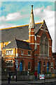
Harringay : Harringay United Church
Built in 1901 as Harringay Congregational Church to a design by architect W.D. Church.
Image: © Jim Osley
Taken: 14 Jan 2021
0.06 miles
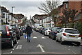
9
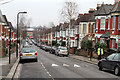
Hewitt Road
One of the streets built circa 1880 as part of the Harringay Park development between Green Lanes and the Great northern mainline. This network of streets is also referred to as the Harringay Ladder because of their ground plan. This view is looking down the hill towards Green Lanes.
Image: © Martin Addison
Taken: 12 Feb 2013
0.07 miles
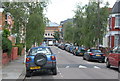
10
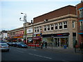
Salisbury Promenade, Green Lanes, N4
Almost all the businesses in this parade of shops are Turkish owned and cater for the large local Turkish community.
Image: © Danny P Robinson
Taken: 13 Jan 2008
0.07 miles