IMAGES TAKEN NEAR TO
Jupiter Way, LONDON, N7 8XW
Introduction
This page details the photographs taken nearby to Jupiter Way, N7 8XW by members of the Geograph project.
The Geograph project started in 2005 with the aim of publishing, organising and preserving representative images for every square kilometre of Great Britain, Ireland and the Isle of Man.

There are currently over 7.5m images from over14,400 individuals and you can help contribute to the project by visiting https://www.geograph.org.uk
Image Map
Images are licensed for reuse under creativecommons.org/licenses/by-sa/2.0
Notes
- Clicking on the map will re-center to the selected point.
- The higher the marker number, the further away the image location is from the centre of the postcode.
Image Listing (154 Images Found)
Images are licensed for reuse under creativecommons.org/licenses/by-sa/2.0
Image
Details
Distance
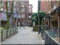
1

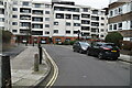
Lockhart Close, Lower Holloway
Unusual design of maisonettes above car parking spaces, off Mackenzie Road.
Image: © Stephen McKay
Taken: 17 Oct 2007
0.06 miles

5
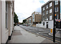
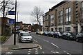
Westbourne Road, Lower Holloway
Looking towards the junction with Mackenzie Road; the terrace is typical of the Victorian housing in the area.
Image: © Stephen McKay
Taken: 17 Oct 2007
0.08 miles
8
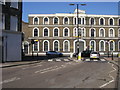
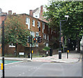
Roman Way
Roman Way at junction with Caledonian Road by the 1874 Mallet Porter and Dowd building
Image: © Shaun Ferguson
Taken: 29 Apr 2009
0.10 miles
10
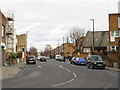
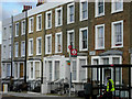
Mackenzie Road, near Holloway
Mackenzie Road is a residential road in inner north London.
Image: © Malc McDonald
Taken: 26 Jan 2019
0.11 miles