IMAGES TAKEN NEAR TO
Roman Way, LONDON, N7 8XH
Introduction
This page details the photographs taken nearby to Roman Way, N7 8XH by members of the Geograph project.
The Geograph project started in 2005 with the aim of publishing, organising and preserving representative images for every square kilometre of Great Britain, Ireland and the Isle of Man.

There are currently over 7.5m images from over14,400 individuals and you can help contribute to the project by visiting https://www.geograph.org.uk
Image Map
Images are licensed for reuse under creativecommons.org/licenses/by-sa/2.0
Notes
- Clicking on the map will re-center to the selected point.
- The higher the marker number, the further away the image location is from the centre of the postcode.
Image Listing (160 Images Found)
Images are licensed for reuse under creativecommons.org/licenses/by-sa/2.0
Image
Details
Distance
1
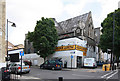
Redundant Church
On the corner of Offord Road and Offord Street.
Was a Congregational Church, the Offord Road Chapel until it closed in 1918.
http://www.aim25.ac.uk/cgi-bin/vcdf/detail?coll_id=12531&inst_id=118&nv1=search&nv2=
Image: © John Salmon
Taken: 9 May 2011
0.01 miles
2
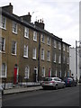
Offord Road N7
Benjamin Britten lived at the house with the black door
Image: © Andrew Wilson
Taken: 16 Feb 2013
0.03 miles
3
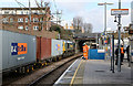
A charter train coasts through Caledonian Road & Barnsbury station
The charter heading for Chingford is hauled by two Class 20/3 diesel locomotives numbers 20308 and 20312.
Image: © Roger Templeman
Taken: 26 Jan 2013
0.03 miles
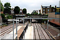
4
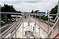
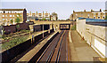
Caledonian Road & Barnsbury Station
Looking west from the footbridge, we see the island platform now used by all North London trains, the left side for westbound trains and the right side for eastbound trains. The track on the extreme left, which was formerly used by westbound passenger trains, is now used by freight trains only, and the platform alongside it is now just used for access.
Image: © Dr Neil Clifton
Taken: 30 Jun 2010
0.03 miles
5
Caledonian Road & Barnsbury station, 1984
View eastward, towards Dalston Junction, Broad Street and East London: ex-North London line, from Camden Road, Willesden, Richmond etc., on the busy middle section of this key inter-regional artery, with the passenger service (from Broad Street) provided only on the No. 2 (south side) lines.
Image: © Ben Brooksbank
Taken: 13 May 1984
0.03 miles
6
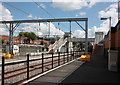
Caledonian Road & Barnsbury Station
Construction engineers discuss the extension of the platform to accommodate the five car class 378 units for London Overground. On the loop line a Freightliner class 66 (66589) stands awaiting its time to proceed with the 4L93 intermodal service from Lawley Street to Felixstowe South Terminal. Entering the loop at Camden Road East Junction at 13:31, this train is booked to wait here until 13:56 to slot in between passenger services and other traffic at Stratford.
Image: © Martin Addison
Taken: 5 Feb 2015
0.03 miles
8
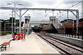
Caledonian Road & Barnsbury Station
London Transport's North London line is subject to an ongoing programme of modernisation, and following a period of closure, the Gospel Oak to Stratford section reopened on 1 June 2010. At Caledonian Road & Barnsbury, the former westbound Platform 1 is now out of use for trains; Platform 2, previously used for eastbound trains, is now the westbound platform, and the other side of this island platform has become Platform 3, for eastbound trains. A new footbridge with lifts has been installed.
Image: © Dr Neil Clifton
Taken: 30 Jun 2010
0.04 miles
9
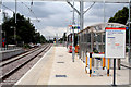
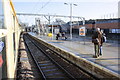
Caledonian Road & Barnsbury Station
Looking west along Platform 2, which is now used for westbound trains. Platform 3 for eastbound trains is out of view on the right.
Image: © Dr Neil Clifton
Taken: 30 Jun 2010
0.04 miles
10
Caledonian Road & Barnsbury Station
Looking east.
Image: © Dr Neil Clifton
Taken: 30 Jun 2010
0.04 miles