IMAGES TAKEN NEAR TO
Bride Street, LONDON, N7 8PY
Introduction
This page details the photographs taken nearby to Bride Street, N7 8PY by members of the Geograph project.
The Geograph project started in 2005 with the aim of publishing, organising and preserving representative images for every square kilometre of Great Britain, Ireland and the Isle of Man.

There are currently over 7.5m images from over14,400 individuals and you can help contribute to the project by visiting https://www.geograph.org.uk
Image Map
Images are licensed for reuse under creativecommons.org/licenses/by-sa/2.0
Notes
- Clicking on the map will re-center to the selected point.
- The higher the marker number, the further away the image location is from the centre of the postcode.
Image Listing (218 Images Found)
Images are licensed for reuse under creativecommons.org/licenses/by-sa/2.0
Image
Details
Distance
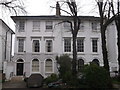
2
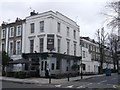
Duchess of Kent Pub, lslington
This public house is at the junction of Liverpool Road and Ellington Street (on the right).
Image: © David Anstiss
Taken: 10 Mar 2013
0.03 miles
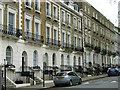
3
No.26 and No.28, Furlong Road, Islington
Two Grade II listed houses along the road.
Part of a group of listed houses on the road.
See http://www.britishlistedbuildings.co.uk/en-368906-numbers-26-and-28-and-attached-railings- for more details about the listed buildings.
Image: © David Anstiss
Taken: 10 Mar 2013
0.04 miles
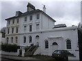
4
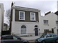
Woodbine Cottage, Islington
No.19 Furlong Road, a Grade II listed house along the road.
Part of a group of listed houses on the road.
See http://www.britishlistedbuildings.co.uk/en-368905-woodbine-cottage-greater-london-authorit for more details about the listed buildings.
Image: © David Anstiss
Taken: 10 Mar 2013
0.06 miles
5
No.318 and No.320, Liverpool Road, Islington
Two Grade II listed houses along the road.
Part of a group of listed houses on the road.
See http://www.britishlistedbuildings.co.uk/en-369076-318-and-320-liverpool-road-greater-londo for more details about the listed buildings.
Image: © David Anstiss
Taken: 10 Mar 2013
0.06 miles
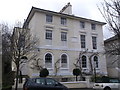
6
Arundel Square, Islington
A substantial Victorian terrace on the east side of this three-sided square. The North London Line forms the south side, although currently construction work is taking place to build on a raft over the railway.
Image: © Stephen McKay
Taken: 31 May 2007
0.06 miles
7

St Mary Magdalene Gardens
When a chapel of ease was established here on Holloway Road in 1814 a burial ground was established around it. it was used as such until 1856 after which the grounds were reordered and re-opened to the public in the 1890s. It is now a pleasant shady refuge on a warm day in the city.
Image: © Stephen McKay
Taken: 7 Sep 2012
0.06 miles
8

By Liverpool Road
St Mary Magdalene Churchyard by Liverpool Road
Image: © Shaun Ferguson
Taken: 29 Apr 2009
0.07 miles
9

Zebra crossing on Liverpool Road, Islington
Image: © David Howard
Taken: 28 Aug 2014
0.08 miles
10
No.18 and No.20, Furlong Road, Islington
Two Grade II listed houses along the road.
Part of a group of listed houses on the road.
See http://www.britishlistedbuildings.co.uk/en-368904-numbers-18-and-20-and-attached-railings- for more details about the listed buildings.
Image: © David Anstiss
Taken: 10 Mar 2013
0.08 miles