1
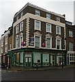
"The Jolly Sisters" public house, London N7
Image: © Jim Osley
Taken: 2 Feb 2011
0.02 miles
2
Lower Holloway Telephone Exchange (1)
Situated in Faraday Close, this TE serves Barnsbury and Lower Holloway, and used to have NORth telephone numbers until the late 1960s. It now has 0207-607, 609 xxxx numbers plus other Inner London numbers, and its postcode is N7 8BH.
Image: © David Hillas
Taken: 4 Nov 2011
0.03 miles
3
Lower Holloway Telephone Exchange (2)
This photo taken in Bride Street, shows this TE which rather resembles a warehouse. Microwave dishes and mobile phone aerials can be seen on the roof of this TE.
Image: © David Hillas
Taken: 4 Nov 2011
0.03 miles
4
Barnsbury - Roman Way
Image: © Peter Whatley
Taken: 11 Apr 2011
0.04 miles
5
Former "Arundel Arms" public house, Holloway
Image: © Jim Osley
Taken: 2 Feb 2011
0.05 miles
6
Mural/protest, Pentonville
At the junction of Roman Way and Wheelwright Street, part of the 'Justice for Henry' campaign by the family of 18 year old Henry Hicks, who died in a police chase in December 2014. Buildings within Pentonville Prison are visible behind the wall.
Image: © Paul Harrop
Taken: 24 Jul 2016
0.05 miles
7
Former pub, Roman Way, N7
At the junction with Wheelwright Street, the former City of Rome pub, also known as the Jug o' Punch, is now in residential use.
Image: © Paul Harrop
Taken: 24 Jul 2016
0.06 miles
8
The Jolly Sisters, Highbury
Image: © Chris Whippet
Taken: 15 Mar 2015
0.06 miles
9
Church conversion, Davey Close, London N7
Built as the Church of St Clement in 1864-1865 to designs by architect by George Gilbert Scott. Grade II listed building, described at this http://list.historicengland.org.uk/resultsingle.aspx?uid=1298052.
Image: © Jim Osley
Taken: 1 Jul 2015
0.06 miles
10
Caledonian Road and Barnsbury Station
Looking east from the station footbridge to the ??? Road bridge.
Image: © Alan Murray-Rust
Taken: 22 Jul 2008
0.06 miles


