IMAGES TAKEN NEAR TO
Hilldrop Road, LONDON, N7 0JG
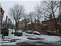
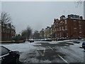
Introduction
This page details the photographs taken nearby to Hilldrop Road, N7 0JG by members of the Geograph project.
The Geograph project started in 2005 with the aim of publishing, organising and preserving representative images for every square kilometre of Great Britain, Ireland and the Isle of Man.

There are currently over 7.5m images from over14,400 individuals and you can help contribute to the project by visiting https://www.geograph.org.uk
Image Map
Images are licensed for reuse under creativecommons.org/licenses/by-sa/2.0
Notes
- Clicking on the map will re-center to the selected point.
- The higher the marker number, the further away the image location is from the centre of the postcode.
Image Listing (61 Images Found)
Images are licensed for reuse under creativecommons.org/licenses/by-sa/2.0
Image
Details
Distance
1
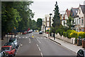
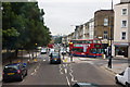
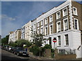
Brecknock Road
Viewed from the top deck of a 390 bus en-route from Archway to Notting Hill Gate. The road on the left is Carleton Road whilst the one on the right is Leighton Grove. The public house, the sign of which is visible in the centre of the photo, is the Leighton Arms.
Brecknock Road is named after the Marquis of Camden who was also the Earl of Brecknock.
Image: © Martin Addison
Taken: 7 Jul 2010
0.14 miles
2
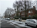
From Charlie Hotel to Shipton Place (4)
Houses in Anson Road
Image: © Basher Eyre
Taken: 20 Jan 2013
0.14 miles
3
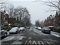
From Charlie Hotel to Shipton Place (3)
Looking from Dalmeny Road into Anson Road
Image: © Basher Eyre
Taken: 20 Jan 2013
0.15 miles
4
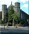
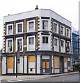
Holloway : former Baptist Church, Camden Road
Grade II listed former Baptist Church built in the 1850s to a design by architect C.G. Searle. Description at this https://historicengland.org.uk/listing/the-list/list-entry/1279707.
Image: © Jim Osley
Taken: 8 Oct 2020
0.15 miles
5
From Charlie Hotel to Shipton Place (5)
Looking from Anson Road into Huddleston Road.
Image: © Basher Eyre
Taken: 20 Jan 2013
0.15 miles
6
From Charlie Hotel to Shipton Place (2)
Crossroads of Anson and Dalmeny Roads
Image: © Basher Eyre
Taken: 20 Jan 2013
0.15 miles
8
Brecknock Road
Viewed from the top deck of a 390 bus en-route to Notting Hill Gate, another 390 on the return journey to Archway can be seen bearing left onto Leighton Road as it enters the one way system at this point.
Brecknock Road was named in 1869 after the Marquis of Camden who was also the Earl of Brecknock. Further down the hill are the traffic lights at the junction with Camden Road.
Image: © Martin Addison
Taken: 7 Jul 2010
0.16 miles
10
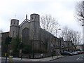
Camden Road Baptist Church
Former Grade II listed Baptist Church and church hall, now hostel (was converted in 1990). It is on the junction of Camden Road and Hilldrop Road (on the right).
See http://www.britishlistedbuildings.co.uk/en-369013-1-and-2-hilldrop-road-greater-london-aut for more details on the church.
Image: © David Anstiss
Taken: 10 Mar 2013
0.17 miles