IMAGES TAKEN NEAR TO
Tufnell Park Road, LONDON, N7 0EE
Introduction
This page details the photographs taken nearby to Tufnell Park Road, N7 0EE by members of the Geograph project.
The Geograph project started in 2005 with the aim of publishing, organising and preserving representative images for every square kilometre of Great Britain, Ireland and the Isle of Man.

There are currently over 7.5m images from over14,400 individuals and you can help contribute to the project by visiting https://www.geograph.org.uk
Image Map
Images are licensed for reuse under creativecommons.org/licenses/by-sa/2.0
Notes
- Clicking on the map will re-center to the selected point.
- The higher the marker number, the further away the image location is from the centre of the postcode.
Image Listing (109 Images Found)
Images are licensed for reuse under creativecommons.org/licenses/by-sa/2.0
Image
Details
Distance
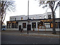
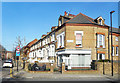
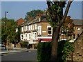
2
Tufnell Park Tavern, Tufnell Park Road N7
At the junction with Campdale Road
Image: © Robin Sones
Taken: 17 Oct 2011
0.06 miles
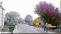
5

Tree on the Corner
A healthy looking specimen in full leaf in the middle of February. Corner of Huddleston Road and St George's Avenue, Tufnell Park.
Image: © Des Blenkinsopp
Taken: 14 Feb 2019
0.08 miles
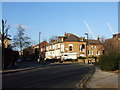
8
Northward on A400 Junction Road at bridge over Tottenham & Hampstead Railway, 2006
The namesake station was on the left here, but closed 3/5/43. The Tottenham & Hampstead line was Joint GER & Midland, forming with the Tottenham & Forest Gate an important artery across North London from the Midland at Kentish Town and Carlton Road Junction to Barking and the Tilbury Line. Nowadays the Gospel Oak - Barking service of London Overground passes along here.
Image: © Ben Brooksbank
Taken: 30 Oct 2000
0.12 miles
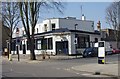
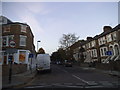
9
Mercers Road at the junction of Dalmeny Road
You can look, you can walk, but you can't drive, the roads here have been made cul de sacs on both sides so only for residents and their visitors. Islington council were (with Camden) one of the first to bring this policy in in London in the 70s, and have not stopped since. The entire borough now has a 20mph limit, as does neighbouring Camden. I would not recommend it to anyone.
Image: © David Howard
Taken: 28 Aug 2014
0.14 miles
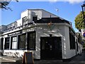
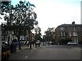
10
Tufnell Park
Showing the junction of Tufnell Park Road, Lady Margaret Road and Warrender Road.
Image: © Stephen McKay
Taken: 16 Oct 2006
0.14 miles