IMAGES TAKEN NEAR TO
Cromwell Avenue, LONDON, N6 5XG
Introduction
This page details the photographs taken nearby to Cromwell Avenue, N6 5XG by members of the Geograph project.
The Geograph project started in 2005 with the aim of publishing, organising and preserving representative images for every square kilometre of Great Britain, Ireland and the Isle of Man.

There are currently over 7.5m images from over14,400 individuals and you can help contribute to the project by visiting https://www.geograph.org.uk
Image Map
Images are licensed for reuse under creativecommons.org/licenses/by-sa/2.0
Notes
- Clicking on the map will re-center to the selected point.
- The higher the marker number, the further away the image location is from the centre of the postcode.
Image Listing (312 Images Found)
Images are licensed for reuse under creativecommons.org/licenses/by-sa/2.0
Image
Details
Distance
1
Dormer windows, Linden Mansions, Highgate
Image: © Jim Osley
Taken: 19 Jan 2017
0.01 miles
2
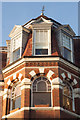
Former Highgate Presbyterian Church, Cromwell Avenue
Built in 1887. Converted into residential use.
Image: © Jim Osley
Taken: 1 Jun 2017
0.01 miles
3
Highgate Hill N6
Looking towards the junction of Dartmouth Park Hill NW6 and St Joseph's Church
Image: © Robin Sones
Taken: 1 Aug 2006
0.02 miles
4

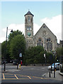
Former church on junction of Hornsey Lane and Cromwell Avenue, London N6
Image: © Robin Sones
Taken: 26 Jun 2006
0.02 miles

6

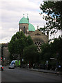
View of a church building on Cromwell Road converted to flats from Waterlow Park
Looking north-northeast.
Image: © Robert Lamb
Taken: 16 May 2015
0.02 miles

8

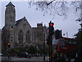
View of a church building on Cromwell Road converted to flats from Highgate Hill
Looking north-northwest.
Image: © Robert Lamb
Taken: 16 May 2015
0.02 miles
9

Victorian house on Hornsey Lane
I discovered for the first time (I was born across the main road from here) this part of Islington borough is still in N6 rather than N19 which begins just beyond the bridge and was also the London/Middlesex boundary till 1965.
Image: © David Howard
Taken: 17 Jul 2018
0.03 miles
10
Church on Hornsey Lane from Dartmouth Park Road
Image: © David Howard
Taken: 25 Apr 2008
0.03 miles