IMAGES TAKEN NEAR TO
Muswell Hill Road, LONDON, N6 5UL
Introduction
This page details the photographs taken nearby to Muswell Hill Road, N6 5UL by members of the Geograph project.
The Geograph project started in 2005 with the aim of publishing, organising and preserving representative images for every square kilometre of Great Britain, Ireland and the Isle of Man.

There are currently over 7.5m images from over14,400 individuals and you can help contribute to the project by visiting https://www.geograph.org.uk
Image Map
Images are licensed for reuse under creativecommons.org/licenses/by-sa/2.0
Notes
- Clicking on the map will re-center to the selected point.
- The higher the marker number, the further away the image location is from the centre of the postcode.
Image Listing (215 Images Found)
Images are licensed for reuse under creativecommons.org/licenses/by-sa/2.0
Image
Details
Distance
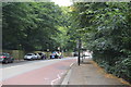
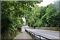
3
Muswell Hill Road
Seen from the junction with South Close and Summersby Road. The trees on the left are in Highgate Wood.
Image: © Martin Addison
Taken: 22 May 2009
0.03 miles
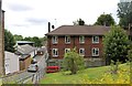
4
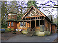
Lodge Cafe in Queen's Wood
The derelict lodge was reclaimed and restored in 1998. There is an organic garden behind the cafe. http://www.fqw.org.uk/
Image: © Phil Champion
Taken: 24 Jan 2009
0.03 miles

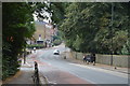
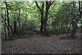
6
Muswell Hill Road
Queen's Wood is on the left, Highgate Wood is on the right, although most of it is actually in Muswell Hill
Image: © David Howard
Taken: 15 Jun 2019
0.04 miles
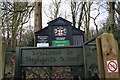
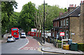
9
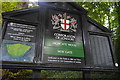
Information Board, New Gate, Highgate Wood
Image: © N Chadwick
Taken: 25 Aug 2016
0.05 miles