IMAGES TAKEN NEAR TO
Southwood Lane, LONDON, N6 5EB
Introduction
This page details the photographs taken nearby to Southwood Lane, N6 5EB by members of the Geograph project.
The Geograph project started in 2005 with the aim of publishing, organising and preserving representative images for every square kilometre of Great Britain, Ireland and the Isle of Man.

There are currently over 7.5m images from over14,400 individuals and you can help contribute to the project by visiting https://www.geograph.org.uk
Image Map
Images are licensed for reuse under creativecommons.org/licenses/by-sa/2.0
Notes
- Clicking on the map will re-center to the selected point.
- The higher the marker number, the further away the image location is from the centre of the postcode.
Image Listing (284 Images Found)
Images are licensed for reuse under creativecommons.org/licenses/by-sa/2.0
Image
Details
Distance
2
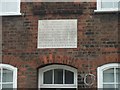
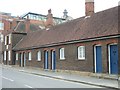
Inscription on almshouses in Southwood Lane
The inscription records the reconstruction of the almshouses; it does not record their subsequent conversion in the late 20th century.
Image: © David Smith
Taken: 27 Apr 2010
0.01 miles
3

Wollaston almshouses, Highgate
Grade II listed building described here http://www.britishlistedbuildings.co.uk/en-201496-sir-john-woolaston-s-almshouses-13-37-ho
Image: © Jim Osley
Taken: 16 Jun 2012
0.02 miles
4
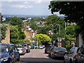
Kingsley Place, Highgate
Seen from Southwood Lane, with a fine view across north London.
Image: © Derek Harper
Taken: 12 Jun 2010
0.02 miles
5
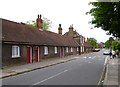
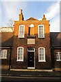
Highgate, almshouses
On Southwood Lane; according to a plaque above the central two-storey building, built by Edward Pauncfort in 1722, to provide twelve dwellings and a schoolhouse. http://www.londonremembers.com/subjects/edward-pauncfort
Image: © Mike Faherty
Taken: 23 Jun 2012
0.03 miles
6
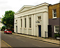
Highgate Baptist Tabernacle (1836)
Converted to a library for the nearby Highgate School. A Grade II listed building documented at this http://list.english-heritage.org.uk/resultsingle.aspx?uid=1358876
Image: © Jim Osley
Taken: 23 Jun 2013
0.03 miles
7

Ordnance Survey Cut Mark
This OS cut mark can be found on the east side of Southwood Lane. It marks a point 124.850m above mean sea level.
Image: © Adrian Dust
Taken: 30 Jul 2016
0.03 miles
8
Alms Houses, Southwood Lane, Hampstead
The school mistresses house is in the centre of twelve former alms houses. Sir John Wollaston built six houses in 1658. By 1722 they had decayed and Edward Pauncefort rebuilt them as a range of twelve houses.
Image: © Richard Rogerson
Taken: 8 Jan 2014
0.03 miles

10
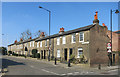
Castle Yard, Highgate
The name is from The Castle pub, demolished 1928.
Simpler in style than a lot of the later domestic architecture nearby, one of these nice little terrace houses would set you back around £850,000.
Image: © Des Blenkinsopp
Taken: 17 Mar 2016
0.04 miles