IMAGES TAKEN NEAR TO
Shepherds Hill, LONDON, N6 5AQ
Introduction
This page details the photographs taken nearby to Shepherds Hill, N6 5AQ by members of the Geograph project.
The Geograph project started in 2005 with the aim of publishing, organising and preserving representative images for every square kilometre of Great Britain, Ireland and the Isle of Man.

There are currently over 7.5m images from over14,400 individuals and you can help contribute to the project by visiting https://www.geograph.org.uk
Image Map
Images are licensed for reuse under creativecommons.org/licenses/by-sa/2.0
Notes
- Clicking on the map will re-center to the selected point.
- The higher the marker number, the further away the image location is from the centre of the postcode.
Image Listing (237 Images Found)
Images are licensed for reuse under creativecommons.org/licenses/by-sa/2.0
Image
Details
Distance
1
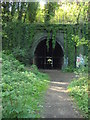
Highgate East Tunnel
One of the original channels that carried water down from behind the tunnel portals to the trackbed drainage system.
Image: © Martin Addison
Taken: 22 May 2009
0.06 miles
2
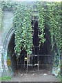
Highgate East Tunnel, southbound bore
You can just see light at the end of the tunnel
Image: © Oxyman
Taken: 22 Apr 2009
0.06 miles
3
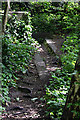
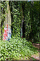
Parkland Walk
Here the path of Parkland Walk leaves the former Great Northern Railway trackbed and turns into Holmesdale Road which is to the left of this image. The entrances to Highgate East Tunnel are behind the natural grouth.
Image: © Oxyman
Taken: 22 Apr 2009
0.06 miles
4
Parkland Walk
Here the path of Parkland Walk leaves the former Great Northern Railway trackbed and turns into Holmesdale Road which is to the right of this image
Image: © Oxyman
Taken: 22 Apr 2009
0.06 miles
5
Highgate East Tunnel
Largely obscured by hanging ivy, the southbound bore of the tunnel is visible. I'm standing on the location of the northbound track, with the edge of the northbound bore just visible on the extreme left of the photo.
Image: © Martin Addison
Taken: 22 May 2009
0.06 miles
7
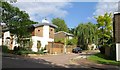
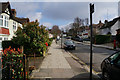
View Close, Highgate
Only the beginning of this cul-de-sac off View Road is in square. The house on the corner, designed by SSH Architects to green specifications and with a distinctive curved metal roof http://www.shh.co.uk/casestudies/houses/view_road/view_road.php , replaced a sixties house in 2007.
Image: © Derek Harper
Taken: 12 Jun 2010
0.07 miles
10
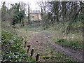
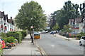
The course of the former Finsbury Park to Alexandra Palace line
Shows the location of (several examples of ) the Image
Image: © Mike Quinn
Taken: 26 Feb 2020
0.08 miles