IMAGES TAKEN NEAR TO
Stapleton Hall Road, LONDON, N4 4QR
Introduction
This page details the photographs taken nearby to Stapleton Hall Road, N4 4QR by members of the Geograph project.
The Geograph project started in 2005 with the aim of publishing, organising and preserving representative images for every square kilometre of Great Britain, Ireland and the Isle of Man.

There are currently over 7.5m images from over14,400 individuals and you can help contribute to the project by visiting https://www.geograph.org.uk
Image Map
Images are licensed for reuse under creativecommons.org/licenses/by-sa/2.0
Notes
- Clicking on the map will re-center to the selected point.
- The higher the marker number, the further away the image location is from the centre of the postcode.
Image Listing (174 Images Found)
Images are licensed for reuse under creativecommons.org/licenses/by-sa/2.0
Image
Details
Distance
1
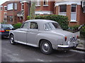
Old Rover P4 car on Stapleton Hall Road, Harringay
I always take old cars when I see them, you can see by the rust on this they don't last forever.
Image: © David Howard
Taken: 2 Apr 2008
0.03 miles
2
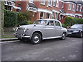
Old Rover car on Stapleton Hall Road, Harringay
Image: © David Howard
Taken: 2 Apr 2008
0.03 miles
3
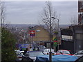
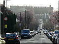
View across Harringay from Quernmore Road
Image: © David Howard
Taken: 2 Apr 2008
0.03 miles

7
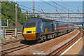
Harringay Station
Express train hurrying towards London.
Image: © Wayland Smith
Taken: 5 Aug 2007
0.04 miles
8
Chettle Court London N8
Looking west down Roseberry Gardens, across Green Lanes and up Duckett Road (which crosses over the New River) the eye first meets the block of flats, "Milverton", on Wightman Road. Looming above that is Chettle Court, a large 1960's Council housing development that stands on the edge of a deep cutting in which runs the Kings Cross to Edinburgh main railway line. Within the space of half a mile that's two roads, one man made river and a railway all heading north- south through Haringey.
Image: © John Kingdon
Taken: 18 Feb 2024
0.05 miles
9
Panorama from Harringay station to Ferme Park Flyover on the ECML
View NNW from the footbridge, towards Wood Green, Hatfield, Hitchin and the North. An Up stopping train, headed by an ex-GN Ivatt Atlantic is approaching on the Up Fast, while one J52 0-6-0T eases its way into Ferme Park Down Yard on the Down Goods No. 2 line (left), while another J52 comes over the Flyover that connected the Down Yard with the Up lines across the main lines. [With apologies for offering, as an 'atmospheric pseudo-painting', an image derived with much editing from a scan of a tiny print - but this gives an impression of the railways in the real Steam Age].
Image: © Ben Brooksbank
Taken: 8 Nov 1947
0.05 miles
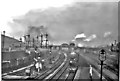
10
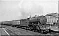
Up Hull express passing Harringay West
View northward, towards Hatfield, Hitchin and the North on the ECML from King's Cross. The 08.47 Hull - King's Cross is headed by Gresley A3 4-6-2 No. 60055 'Woolwinder' (built 12/24 as A1 No. 2554, rebuilt 6/42, fitted with double-chimney 6/58, withdrawn 9/61). Behind it is the south end of the Ferme Park Flyover; behind that is a modern house built where there was severe WW2 bomb damage that affected the flyover.
Image: © Ben Brooksbank
Taken: 27 Feb 1960
0.06 miles