IMAGES TAKEN NEAR TO
Darren Close, Ossian Road, LONDON, N4 4EF
Introduction
This page details the photographs taken nearby to Darren Close, Ossian Road, N4 4EF by members of the Geograph project.
The Geograph project started in 2005 with the aim of publishing, organising and preserving representative images for every square kilometre of Great Britain, Ireland and the Isle of Man.

There are currently over 7.5m images from over14,400 individuals and you can help contribute to the project by visiting https://www.geograph.org.uk
Image Map
Images are licensed for reuse under creativecommons.org/licenses/by-sa/2.0
Notes
- Clicking on the map will re-center to the selected point.
- The higher the marker number, the further away the image location is from the centre of the postcode.
Image Listing (91 Images Found)
Images are licensed for reuse under creativecommons.org/licenses/by-sa/2.0
Image
Details
Distance
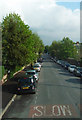
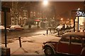
2
Snow on cars - the kind of snow that's good for making snowballs
Image: © Slbs
Taken: Unknown
0.04 miles
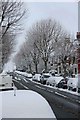
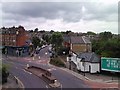
3
Ossian Road from Parkland Walk
Crouch End covered reservoir is opposite
Image: © David Howard
Taken: 5 Jul 2012
0.08 miles
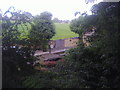
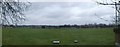
4
Crouch Hill Covered Reservoir
The grassy field below an expansive sky is actually the roof of the covered reservoir. To the left is a hatchway into the reservoir and in the far distance the tall buildings of Canary Wharf.
Image: © John Kingdon
Taken: 26 Sep 2023
0.08 miles
5
Stapleton Hall Road and view of Stroud Green, viewed from Parkland Walk
This photo is a pan west from Image, showing Stapleton Hall Road and a view of the immediate settlement of Stroud Green. Notice the coincidental abundance here of gaps between letters on both the Corsodyl mouthwash billboard and the launderette's shopfront! View looking north-northeast.
Image: © Robert Lamb
Taken: 27 Jul 2010
0.08 miles
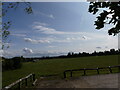
6
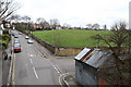
Mount Pleasant Villas
Seen from The Parkland Walk - previously the GNR's Finsbury Park to Alexandra Palace branch. The large green area to the centre right of the photo is a covered reservoir built some time prior to 1885. The railway line had a signal box near here called 'Reservoir' prior to the opening of Stroud Green station.
Image: © Martin Addison
Taken: 28 Jan 2011
0.08 miles
7
View over Crouch End Reservoirs
Looking from Mount View Road over the covered water reservoirs towards central London.
Image: © David Anstiss
Taken: 10 Mar 2013
0.09 miles
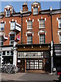
8
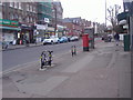
Shops on Ferme Park Road, Stroud Green
This road links Finsbury Park with Hornsey and Crouch End
Image: © David Howard
Taken: 16 Feb 2012
0.09 miles
10
The Nicholas Nickleby Pub (Now Closed)
This little 'back street' pub has recently closed and is now advertised as a shop unit to let. It is some years since I last drank there but it was a cosy little pub and its charming frontage will doubtless soon be gone forever.
Image: © John Kingdon
Taken: 26 Sep 2023
0.09 miles