IMAGES TAKEN NEAR TO
Connaught Road, LONDON, N4 4AW
Introduction
This page details the photographs taken nearby to Connaught Road, N4 4AW by members of the Geograph project.
The Geograph project started in 2005 with the aim of publishing, organising and preserving representative images for every square kilometre of Great Britain, Ireland and the Isle of Man.

There are currently over 7.5m images from over14,400 individuals and you can help contribute to the project by visiting https://www.geograph.org.uk
Image Map
Images are licensed for reuse under creativecommons.org/licenses/by-sa/2.0
Notes
- Clicking on the map will re-center to the selected point.
- The higher the marker number, the further away the image location is from the centre of the postcode.
Image Listing (101 Images Found)
Images are licensed for reuse under creativecommons.org/licenses/by-sa/2.0
Image
Details
Distance
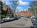
1
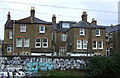
Houses on Beatrice Road
Backing on to the East Coast Main Line.
Image: © JThomas
Taken: 13 Apr 2019
0.09 miles
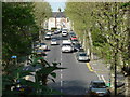
2
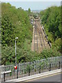
View From Stroud Green
Looking down on the Tottenham and Hampstead Railway from the Great Northern Railway's Finsbury Park to Alexandra Palace branch. The latter is now a footpath known as The Parkland Walk and was a victim of Dr. Beeching's cuts. The Tottenham and Hampstead Railway's line survived because of its importance as a freight link across London. This view is taken from the site of the platforms of Stroud Green station. The diesel multiple unit is a class 172. The type recently replaced class 150's on the Barking - Gospel Oak service.
Image: © Martin Addison
Taken: 28 Jan 2011
0.11 miles
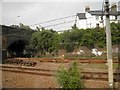
3
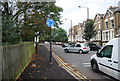
Gospel Oak to Barking Line from Parkland Walk
Seen from Parkland Walk which was itself formerly a railway line. Lancaster Road is in the foreground
Image: © Oxyman
Taken: 22 Apr 2009
0.11 miles
4
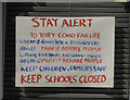
Stroud Green : Covid-19 window poster
One of numerous posters placed in residential windows during the coronavirus pandemic of 2020.
Image: © Jim Osley
Taken: 24 Jun 2020
0.11 miles
6
Upper Tollington Park from Parkland Walk
Seen from the top of a former Great Northern Railway bridge that is now part of Parkland Walk
Image: © Oxyman
Taken: 22 Apr 2009
0.13 miles
7
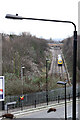
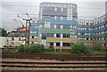
The East Coast main railway line in Finsbury Park area
Image: © Steve Fareham
Taken: 18 Jun 2013
0.14 miles
8
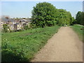
Parkland Walk
A 4.5-mile (7.2 km) linear green walkway along the trackbed of a former Great Northern Railway line.
Image: © Oxyman
Taken: 22 Apr 2009
0.14 miles
10
Colourful buildings by the East Coast Main Line
Image: © N Chadwick
Taken: 28 May 2014
0.14 miles