IMAGES TAKEN NEAR TO
Wray Crescent, LONDON, N4 3LP
Introduction
This page details the photographs taken nearby to Wray Crescent, N4 3LP by members of the Geograph project.
The Geograph project started in 2005 with the aim of publishing, organising and preserving representative images for every square kilometre of Great Britain, Ireland and the Isle of Man.

There are currently over 7.5m images from over14,400 individuals and you can help contribute to the project by visiting https://www.geograph.org.uk
Image Map
Images are licensed for reuse under creativecommons.org/licenses/by-sa/2.0
Notes
- Clicking on the map will re-center to the selected point.
- The higher the marker number, the further away the image location is from the centre of the postcode.
Image Listing (89 Images Found)
Images are licensed for reuse under creativecommons.org/licenses/by-sa/2.0
Image
Details
Distance
1
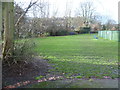
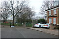
Wray Crescent Open Space
This is Wray Crescent Open Space. The photograph is taken from the end of Tollington Place. The houses seen here across the park are in Wray Crescent.
Image: © Marathon
Taken: 28 Jan 2015
0.02 miles
2
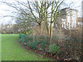
Wray Crescent Open Space
This is Wray Crescent Open Space. To the right of the railings is Tollington Place, which leads to Tollington Park - see http://www.geograph.org.uk/photo/4328571
Image: © Marathon
Taken: 28 Jan 2015
0.06 miles
4
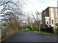
The end of Tollington Place
Wray Crescent Open Space is to the left and ahead on the other side of the fence. Tollington Place to the right leads to Tollington Park.
Image: © Marathon
Taken: 28 Jan 2015
0.08 miles
5
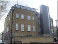
Upper Holloway Telephone Exchange (1)
Situated in Pine Grove off Tollington Park, this TE, which dates from the 1930s, used to have ARChway numbers until the late 1960s. It now has 0207-263, 272, 281 and other Inner London numbers. Mobile phone aerials and a microwave dish can be seen on its roof. Its postcode is N4 3LL.
Image: © David Hillas
Taken: 3 Apr 2012
0.09 miles
7
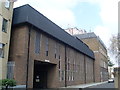
Upper Holloway Telephone Exchange (2)
Taken in Pine Grove, this photo shows the extension on the left which was added more recently after the original TE on the right was built in the 1930s. Besides Upper Holloway, this TE also serves the Finsbury Park and Tufnell Park areas.
Image: © David Hillas
Taken: 3 Apr 2012
0.10 miles
8
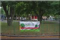
Wray Crescent Open Space
At the end of Turle Road
Image: © David Howard
Taken: 2 Jan 2021
0.10 miles
9
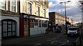
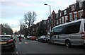
The former Plough Pub and Stables on the Hornsey Road
Looking down the Hornsey Road where Tollington Park comes in from the left. The Plough pub closed last year after an effort in vain to keep it open as a Sports bar. To the left of the pub flats now occupy what was once the Plough Stables. I imagine the stables closed down about a century before the pub succumbed.
Image: © John Kingdon
Taken: 1 Feb 2018
0.10 miles
10
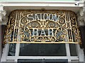
Wrought iron grille "SALOON BAR"
To be found at the former "Hanley Arms" public house, a Grade II listed building, Horsey Road, London N19
Image: © Jim Osley
Taken: 7 Aug 2010
0.10 miles