IMAGES TAKEN NEAR TO
Green Lanes, LONDON, N4 2LL
Introduction
This page details the photographs taken nearby to Green Lanes, N4 2LL by members of the Geograph project.
The Geograph project started in 2005 with the aim of publishing, organising and preserving representative images for every square kilometre of Great Britain, Ireland and the Isle of Man.

There are currently over 7.5m images from over14,400 individuals and you can help contribute to the project by visiting https://www.geograph.org.uk
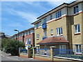
Image Map
Images are licensed for reuse under creativecommons.org/licenses/by-sa/2.0
Notes
- Clicking on the map will re-center to the selected point.
- The higher the marker number, the further away the image location is from the centre of the postcode.
Image Listing (168 Images Found)
Images are licensed for reuse under creativecommons.org/licenses/by-sa/2.0
Image
Details
Distance
1
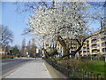
Blossom on Green Lanes
Green Lanes is an ancient thoroughfare which was originally a drovers' road along which cattle were walked from Hertfordshire towards Smithfield Market. It is plural because it was originally a number of lanes. This is just past Clissold Park, looking in the direction of Manor House and Finsbury Park.
Image: © Marathon
Taken: 18 Mar 2015
0.04 miles
3
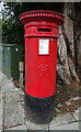
Victorian postbox on Green Lanes
Postbox No. N4 26.
See Image] for context.
Image: © JThomas
Taken: 20 Jul 2019
0.05 miles
4
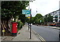
Green Lanes, London N4
Showing position of Postbox No. N4 26.
See Image] for postbox.
Image: © JThomas
Taken: 20 Jul 2019
0.06 miles
6
View of flats on Green Lanes and the Castle Climbing Centre from the New River Walkway
Looking south-southwest.
Image: © Robert Lamb
Taken: 15 Jun 2013
0.08 miles
8
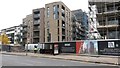
Myddleton Avenue / Green Lanes, N4
The roughly square area to the west of Green Lanes, bordered to the north by Gloucester Drive and to the south by Digby Crescent, which used to contain filter beds for the New River waterworks in Image (photographed by Malc McDonald), has been redeveloped into housing - see the map and satellite image http://mortimermaps.appspot.com/wtp3/wtp3.htm?lat=51.565102&lon=-0.095456&lz=17&rz=17<=OS&rt=satellite&lov=None&rov=None .
See also Image
Image: © Mike Quinn
Taken: 18 Jun 2015
0.08 miles
10
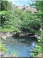
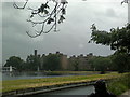
The New River north of The Castle
See Image
The New River is neither new (having been built at the beginning of the 17th C) nor a river (it's an aqueduct supplying water to London, taken from the River Lea near Hertford and from Chadwell Spring, Amwell Spring, and other springs and wells along its course). For further info, see the Wiki entry http://en.wikipedia.org/wiki/New_River_(England) .
Image: © Mike Quinn
Taken: 18 Jun 2015
0.08 miles