IMAGES TAKEN NEAR TO
Devan Grove, LONDON, N4 2GS
Introduction
This page details the photographs taken nearby to Devan Grove, N4 2GS by members of the Geograph project.
The Geograph project started in 2005 with the aim of publishing, organising and preserving representative images for every square kilometre of Great Britain, Ireland and the Isle of Man.

There are currently over 7.5m images from over14,400 individuals and you can help contribute to the project by visiting https://www.geograph.org.uk
Image Map
Images are licensed for reuse under creativecommons.org/licenses/by-sa/2.0
Notes
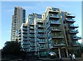
- Clicking on the map will re-center to the selected point.
- The higher the marker number, the further away the image location is from the centre of the postcode.
Image Listing (252 Images Found)
Images are licensed for reuse under creativecommons.org/licenses/by-sa/2.0
Image
Details
Distance
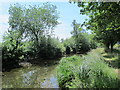
4
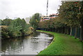
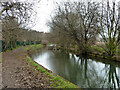
The New River east of Woodberry Grove, N4 (2)
See Image
Image: © Mike Quinn
Taken: 18 Jun 2015
0.03 miles
6
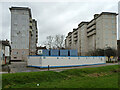
Flats, Woodberry Down, 2011
These were later demolished.
Image: © Robin Webster
Taken: 5 Feb 2011
0.04 miles
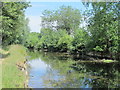
8
The New River south of Newnton Close, N4 (2)
See Image
Image: © Mike Quinn
Taken: 18 Jun 2015
0.04 miles
9
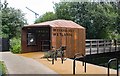
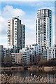
Woodberry Down Estate
The Woodberry Down Estate has been developed since 2009 on the site of a former Council estate. This photograph is near the entrance to the Woodberry Wetlands Nature Reserve.
Image: © Marathon
Taken: 1 Nov 2021
0.04 miles
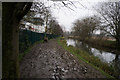
10
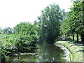
New River, north of Lordship Road, 2011
It seems a footbridge was later built here.
Image: © Robin Webster
Taken: 5 Feb 2011
0.05 miles