IMAGES TAKEN NEAR TO
Umfreville Road, LONDON, N4 1RY
Introduction
This page details the photographs taken nearby to Umfreville Road, N4 1RY by members of the Geograph project.
The Geograph project started in 2005 with the aim of publishing, organising and preserving representative images for every square kilometre of Great Britain, Ireland and the Isle of Man.

There are currently over 7.5m images from over14,400 individuals and you can help contribute to the project by visiting https://www.geograph.org.uk
Image Map (Loading...)


Getting Data...Please wait
Leaflet Map data © OpenStreetMap
Images are licensed for reuse under creativecommons.org/licenses/by-sa/2.0
Notes
- Clicking on the map will re-center to the selected point.
- The higher the marker number, the further away the image location is from the centre of the postcode.
Image Listing (273 Images Found)
Images are licensed for reuse under creativecommons.org/licenses/by-sa/2.0
Image
Details
Distance
1
Bridge over the New River, Umfreville Road, N4
Image: © Mike Quinn
Taken: 18 Jun 2015
0.01 miles
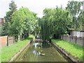
2

New River, Harringay
This man-made river, built to supply London with Hertfordshire water, passes the back gardens of Harringay, largely unnoticed.
Image: © Stephen McKay
Taken: 27 Aug 2011
0.01 miles
3
The New River south of Burgoyne Road, N4
Image: © Mike Quinn
Taken: 18 Jun 2015
0.01 miles
4

The New River north of Umfreville Road, N4
Image: © Mike Quinn
Taken: 18 Jun 2015
0.03 miles
5
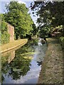
The New River
Opened 1613 to supply drinking water to London from the river Lea.
Wikipedia entry: https://en.wikipedia.org/wiki/New_River_(London)
Image: © David Robinson
Taken: 16 Jun 2022
0.04 miles
6

Bridge over the New River, Burgoyne Road, N4
See Image
Image: © Mike Quinn
Taken: 18 Jun 2015
0.04 miles
7
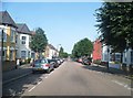
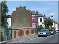
Burgoyne Road, Harringay
The 18/19th road on the Harringay Ladder between Wightman Road and Green Lanes
Image: © David Howard
Taken: 11 Jul 2013
0.04 miles
8

The New River south of Cavendish Road, N4
Image: © Mike Quinn
Taken: 18 Jun 2015
0.06 miles
9
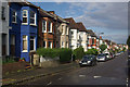
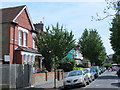
Umfreville Road, Harringay
A burst of sunshine following a rain shower catches the houses on the northern side of Umfreville Road. This is one of a set of twenty parallel streets, running between Green Lanes and Wightman Road, known collectively as the 'Harringay Ladder' because on a map or from the air that is what they resemble.
Image: © Stephen McKay
Taken: 27 Aug 2011
0.06 miles