IMAGES TAKEN NEAR TO
Mattison Road, LONDON, N4 1BG
Introduction
This page details the photographs taken nearby to Mattison Road, N4 1BG by members of the Geograph project.
The Geograph project started in 2005 with the aim of publishing, organising and preserving representative images for every square kilometre of Great Britain, Ireland and the Isle of Man.

There are currently over 7.5m images from over14,400 individuals and you can help contribute to the project by visiting https://www.geograph.org.uk
Image Map
Images are licensed for reuse under creativecommons.org/licenses/by-sa/2.0
Notes
- Clicking on the map will re-center to the selected point.
- The higher the marker number, the further away the image location is from the centre of the postcode.
Image Listing (254 Images Found)
Images are licensed for reuse under creativecommons.org/licenses/by-sa/2.0
Image
Details
Distance
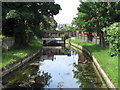
1
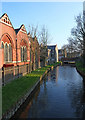
The New River south of Pemberton Road, N4
Image: © Mike Quinn
Taken: 18 Jun 2015
0.02 miles
2
The New River north of Duckett Road, N4
Image: © Mike Quinn
Taken: 18 Jun 2015
0.02 miles
3
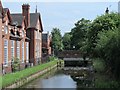
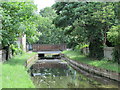
Bridge over the New River, Mattison Road, N4
See Image
Image: © Mike Quinn
Taken: 18 Jun 2015
0.03 miles
4
I dreamed I saw St. Augustine (again)
The Roman Catholic church of St. Augustine of Canterbury in Mattison Road N4 http://catholicdirectory.org/Catholic_Information.asp?ID=38082 next to the New River. See also Image
Image: © Mike Quinn
Taken: 18 Jun 2015
0.03 miles
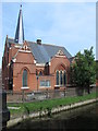
5
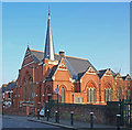
Disused church, Mattison Road
The image features the former Roman Catholic church of St Augustine of Canterbury. "Built as a Methodist church in 1900, sold to the Roman Catholics in 1963 and closed in 2009" - quoted from this https://londonchurchbuildings.wordpress.com/2013/09/13/st-augustine-of-canterbury-former-mattison-road-haringey-roman-catholic/.
Image: © Jim Osley
Taken: 17 Mar 2016
0.03 miles
7
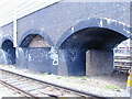
Harringay Flyover
If you travel out of Kings Cross you will have been under it but probably not over it as it is normally only used by empty trains to or from the depot. It has an old air raid shelter built in.
Image: © Gareth Foster
Taken: 23 Mar 2004
0.03 miles
8
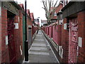
Harringay Passage (1)
This footpath runs all the way through the roads on the "Harringay Ladder" as the street system here is known.
Image: © Danny P Robinson
Taken: 24 Mar 2008
0.04 miles
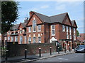
9
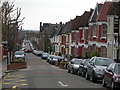
Mattison Road, N4 (2)
Looking across Green Lanes towards Chesterfield Road.
Image: © Danny P Robinson
Taken: 24 Mar 2008
0.04 miles
10
The New River south of Mattison Road, N4
Image: © Mike Quinn
Taken: 18 Jun 2015
0.04 miles