IMAGES TAKEN NEAR TO
Windermere Avenue, LONDON, N3 3RD
Introduction
This page details the photographs taken nearby to Windermere Avenue, N3 3RD by members of the Geograph project.
The Geograph project started in 2005 with the aim of publishing, organising and preserving representative images for every square kilometre of Great Britain, Ireland and the Isle of Man.

There are currently over 7.5m images from over14,400 individuals and you can help contribute to the project by visiting https://www.geograph.org.uk
Image Map
Images are licensed for reuse under creativecommons.org/licenses/by-sa/2.0
Notes
- Clicking on the map will re-center to the selected point.
- The higher the marker number, the further away the image location is from the centre of the postcode.
Image Listing (56 Images Found)
Images are licensed for reuse under creativecommons.org/licenses/by-sa/2.0
Image
Details
Distance
1
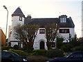
'The Dell' Orchard Avenue, Finchley
An unusual suburban house with a corner turret. c 1920s.
Image: © Graham Hale
Taken: 15 Nov 2009
0.05 miles
2
St Luke, Mountfield, London N3
Disused church
Image: © John Salmon
Taken: 31 Jul 2004
0.08 miles
3
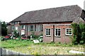
St Luke, Mountfield, London N3
Disused church
Image: © John Salmon
Taken: 31 Jul 2004
0.08 miles
4
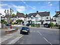
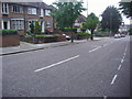
Windermere Avenue at the junction of Holly Park
Image: © David Howard
Taken: 13 May 2022
0.10 miles
5

Basing Way
The Amberden Avenue end of this housing estate. The left hand no entry sign is glowing because of the angle at which the sun is striking its reflective coating.
Image: © Martin Addison
Taken: 27 Jul 2008
0.14 miles
6

Kingsgate Property
A large property on the corner of Kingsgate Avenue and Beechwood Avenue undergoes renovation. It is a typical 1950's Mock-Tudor building and during the renovation work has had its false wooden beams removed revealing the fact that the top half of the house is not wattle and daub at all, but bricks and mortar.
Image: © Martin Addison
Taken: 27 Jul 2008
0.16 miles
7
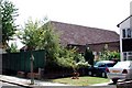
Amberden Avenue
A group of buildings in the corner between Amberden Avenue and Kingsgate Avenue. I believe they were originally built as a section house for the police. Whether that remains their function is unclear as there is no signage to indicate their current use.
Image: © Martin Addison
Taken: 26 Jul 2008
0.17 miles
10
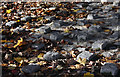
Cobbles and Leaves
Autumn leaves collect amongst the cobbles under the footbridge over the North Circular Road. This pattern of raised cobbles is popular in paved areas where people do not normally walk as they discourage people from sleeping rough.
Image: © Martin Addison
Taken: 29 Nov 2007
0.18 miles