IMAGES TAKEN NEAR TO
Allandale Avenue, LONDON, N3 3PJ
Introduction
This page details the photographs taken nearby to Allandale Avenue, N3 3PJ by members of the Geograph project.
The Geograph project started in 2005 with the aim of publishing, organising and preserving representative images for every square kilometre of Great Britain, Ireland and the Isle of Man.

There are currently over 7.5m images from over14,400 individuals and you can help contribute to the project by visiting https://www.geograph.org.uk
Image Map
Images are licensed for reuse under creativecommons.org/licenses/by-sa/2.0
Notes
- Clicking on the map will re-center to the selected point.
- The higher the marker number, the further away the image location is from the centre of the postcode.
Image Listing (120 Images Found)
Images are licensed for reuse under creativecommons.org/licenses/by-sa/2.0
Image
Details
Distance
1
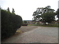
College Farm, Finchley
You can just see the church spire opposite in Hampstead Garden Suburb
Image: © David Howard
Taken: 18 Aug 2015
0.05 miles
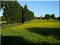
2
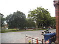
College Farm, Finchley
After a long fight with the council this remains one of the closest working farms to London
Image: © David Howard
Taken: 18 Aug 2015
0.06 miles
3
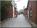
College Farm, Finchley
This is a pet food and garden shop on either side of the path
Image: © David Howard
Taken: 18 Aug 2015
0.07 miles
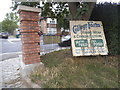
4

Fitzalan Road, Finchley
Looking towards Regents Park Road
Image: © David Howard
Taken: 14 Jan 2022
0.07 miles
6
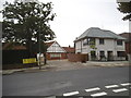
The entrance to College Farm, Finchley
All the houses on the right have just been completed.
Image: © David Howard
Taken: 18 Aug 2015
0.10 miles
7
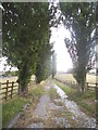
The old entrance to College Farm, Finchley
After a long battle with the council College Farm was saved from the developers and still hosts regular school visits and supplies its own dairy herd produce. The new entrance is on Fitzalan Road.
Image: © David Howard
Taken: 5 Aug 2015
0.11 miles
8
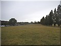
Fields at College Farm
This is one of the few surviving farms in north London
Image: © David Howard
Taken: 5 Aug 2015
0.11 miles
9
College Farm
Originally Sheephouse Farm, it was converted to a Model Dairy farm by Express Dairies in 1882/3. It subsequently became a visitor centre from 1909, displaying the dairy industry to the public. It is currently closed to the public. The full story of its history to the present day can be found on the College Farm Trust's website http://www.collegefarmtrust.co.uk/ .
Image: © Martin Addison
Taken: 23 May 2007
0.13 miles
10
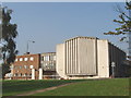
Finchley Synagogue
A large synagogue seating 1350 people. Taken on a Saturday, the synagogue was evident from black coated worshippers walking home in the streets around. A constituent of the United Synagogue, built in 1967 to replace one built in 1935. At the corner of Kinloss Gardens and Charter Way - at the A598 A406 road junction.
Image: © David Hawgood
Taken: 15 Oct 2005
0.13 miles