IMAGES TAKEN NEAR TO
Mountfield Road, LONDON, N3 3NR
Introduction
This page details the photographs taken nearby to Mountfield Road, N3 3NR by members of the Geograph project.
The Geograph project started in 2005 with the aim of publishing, organising and preserving representative images for every square kilometre of Great Britain, Ireland and the Isle of Man.

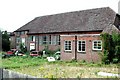
There are currently over 7.5m images from over14,400 individuals and you can help contribute to the project by visiting https://www.geograph.org.uk
Image Map
Images are licensed for reuse under creativecommons.org/licenses/by-sa/2.0
Notes
- Clicking on the map will re-center to the selected point.
- The higher the marker number, the further away the image location is from the centre of the postcode.
Image Listing (86 Images Found)
Images are licensed for reuse under creativecommons.org/licenses/by-sa/2.0
Image
Details
Distance
1
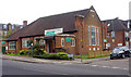
St Luke, Mountfield, London N3
Disused church
Image: © John Salmon
Taken: 31 Jul 2004
0.06 miles
2
St Luke, Mountfield, London N3
Disused church
Image: © John Salmon
Taken: 31 Jul 2004
0.06 miles
4

Ordnance Survey Cut Mark
This OS cut mark can be found on the north side of the road. It has been cancelled with a cross running above the cut.
Image: © Adrian Dust
Taken: 2 Aug 2016
0.10 miles
5

Avenue House stables, Finchley
Now containing the offices for Stephens House, where the ink manufacturer is from.
Image: © David Howard
Taken: 23 Jun 2020
0.10 miles
6
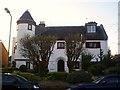
'The Dell' Orchard Avenue, Finchley
An unusual suburban house with a corner turret. c 1920s.
Image: © Graham Hale
Taken: 15 Nov 2009
0.11 miles
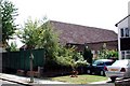
8
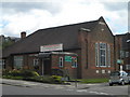
Finchley Baptist Church, East End Road N3
At the junction of Stanhope Avenue
Image: © Robin Sones
Taken: 29 Aug 2010
0.12 miles
10
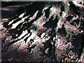
Roots
In Avenue House park, the roots of a Horse Chestnut are exposed by erosion of the soil. There are a number of hillocks within the park and all similarly display exposed tree roots.
Image: © Martin Addison
Taken: 12 Jul 2006
0.12 miles