IMAGES TAKEN NEAR TO
Highview Gardens, LONDON, N3 3EX
Introduction
This page details the photographs taken nearby to Highview Gardens, N3 3EX by members of the Geograph project.
The Geograph project started in 2005 with the aim of publishing, organising and preserving representative images for every square kilometre of Great Britain, Ireland and the Isle of Man.

There are currently over 7.5m images from over14,400 individuals and you can help contribute to the project by visiting https://www.geograph.org.uk
Image Map
Images are licensed for reuse under creativecommons.org/licenses/by-sa/2.0
Notes
- Clicking on the map will re-center to the selected point.
- The higher the marker number, the further away the image location is from the centre of the postcode.
Image Listing (96 Images Found)
Images are licensed for reuse under creativecommons.org/licenses/by-sa/2.0
Image
Details
Distance
1
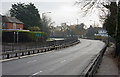
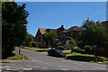
A1 Barnet Bypass
It seems strange to be talking about the Barnet Bypass here on the border between Finchley and Hendon. By a strange quirk of the traffic lights at the A406 Junction, which this view is looking towards, and those at the Junction with the A504 there isn't a single car in view! There's always one street lamp that thinks it's still night. The road on the left is Highview Gardens whilst in the distance on the right are Southbourne Crescent and Greenbank Crescent, the houses of which are visible following the line of the dual carriageway.
Image: © Martin Addison
Taken: 14 Dec 2008
0.05 miles
2
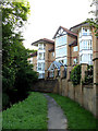
Riverside Gardens
Apartments on a private estate beside Dollis Brook. The brook passes around an island at this point with the narrower of the flows beside the footpath, on the left of the photo.
Image: © Martin Addison
Taken: 1 Jun 2007
0.05 miles
3
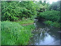
Dollis Brook by Hendon Lane
There used to be a garden centre on the left but is now another housing estate
Image: © David Howard
Taken: 25 Jun 2013
0.06 miles
4
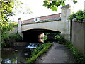
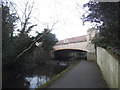
Dollis Brook
Beside the brook at Hendon Lane weir. The bridge reflected in the water carries the A1 over the brook - see Image for a view of this bridge.
Image: © Martin Addison
Taken: 29 Jun 2008
0.06 miles
5
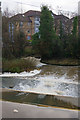
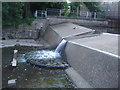
Dollis Brook
Hendon Lane Weir with the brook in full spate after continuous heavy rain the previous day. Spume has collected in the weeds on the slow moving branch of the brook where it passes the island in mid stream. More spume coming downstream can be seen in the foreground. The main flow of the brook passes on the right hand side of the island. Compare this with the peaceful summer scene - Image taken from the Dollis Valley green Path. Behind the trees are the apartments on Riverside Gardens.
Image: © Martin Addison
Taken: 14 Dec 2008
0.06 miles
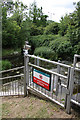
6
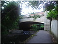
The A1 Crossing Dollis Brook
Bridge carrying the A1 over Dollis Brook. The bridge carries the Middlesex coat of arms, although the area is firmly part of the London Borough of Barnet.
Image: © Martin Addison
Taken: 1 Jun 2007
0.06 miles
7
The Great North Way going over Dollis Brook
Image: © David Howard
Taken: 25 Jun 2013
0.06 miles
8
Junction of Crooked Usage with Hendon Lane
Image: © Christopher Hilton
Taken: 22 May 2017
0.07 miles
10
Bridge over the River Brent, Hendon
The Great North Way goes over the path which continues to Finchley.
Image: © David Howard
Taken: 10 Mar 2015
0.07 miles