IMAGES TAKEN NEAR TO
Dolman Close, LONDON, N3 2EX
Introduction
This page details the photographs taken nearby to Dolman Close, N3 2EX by members of the Geograph project.
The Geograph project started in 2005 with the aim of publishing, organising and preserving representative images for every square kilometre of Great Britain, Ireland and the Isle of Man.

There are currently over 7.5m images from over14,400 individuals and you can help contribute to the project by visiting https://www.geograph.org.uk
Image Map
Images are licensed for reuse under creativecommons.org/licenses/by-sa/2.0
Notes
- Clicking on the map will re-center to the selected point.
- The higher the marker number, the further away the image location is from the centre of the postcode.
Image Listing (174 Images Found)
Images are licensed for reuse under creativecommons.org/licenses/by-sa/2.0
Image
Details
Distance
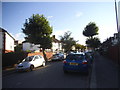
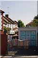
2
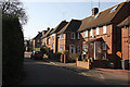
Avondale Road
The short stub of Avondale Road on the south side of the junction with Abingdon Road. Just visible under the trees at the end of the road is the entrance to Dolman Close. There is also a connecting road to Pointalls close out of shot on the right. The housing consists of this short mock tudor terrace - there are no houses on the other side of the road.
Image: © Martin Addison
Taken: 20 Sep 2008
0.02 miles
3
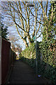
Un-named Footpath
A short footpath behind gardens on Pointalls Close connecting Avondale Road with the North Circular Road.
Image: © Martin Addison
Taken: 12 Feb 2008
0.03 miles
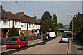
4
Pointalls Close
A small housing estate between Abingdon Road and Finchley Fire Station's yard. The close is L shaped and used to connect to the North Circular Road, out of shot on the left and the fire station. When the North Circular was widened to a 6 lane Dual Carriageway, a new section of access road was provided connecting the close to Avondale Road and access to the North Circular removed.
Image: © Martin Addison
Taken: 12 Feb 2008
0.03 miles
5
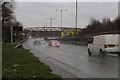
Driving Rain
The North Circular Road in Finchley at midday on January 1st 2014 with an overcast sky and heavy rain.
Image: © Martin Addison
Taken: 1 Jan 2014
0.03 miles
6
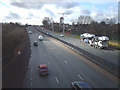
North Circular Road
The A406 in 2006, now a six lane road. Most of the Poplar trees have gone, though new trees of other species are being planted. The bus stops halfway up the hill are next to Long Lane which the A406 now bridges. The crest of the hill is the bridge over the Northern Line. The tower at the centre is in Finchley Fire Station for training firemen.
Image: © Martin Addison
Taken: 16 Feb 2006
0.04 miles
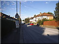
7
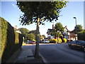
Avondale Road at the junction of Abingdon Road
Image: © David Howard
Taken: 21 Aug 2015
0.04 miles
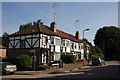
8
Garage and the Back of Avondale Road
A garage on Cromwell Road. The slope of Avondale Road permits a view of the rear of its terraced houses.
Image: © Martin Addison
Taken: 20 Sep 2008
0.04 miles
9
Abingdon Road
East of the junction with Avondale Road, Abingdon slopes down to the side entrance of the Tudor Primary School - one of the classrooms is visible beyond the fence.
Image: © Martin Addison
Taken: 20 Sep 2008
0.04 miles