IMAGES TAKEN NEAR TO
Dollis Avenue, LONDON, N3 1TX
Introduction
This page details the photographs taken nearby to Dollis Avenue, N3 1TX by members of the Geograph project.
The Geograph project started in 2005 with the aim of publishing, organising and preserving representative images for every square kilometre of Great Britain, Ireland and the Isle of Man.

There are currently over 7.5m images from over14,400 individuals and you can help contribute to the project by visiting https://www.geograph.org.uk
Image Map
Images are licensed for reuse under creativecommons.org/licenses/by-sa/2.0
Notes
- Clicking on the map will re-center to the selected point.
- The higher the marker number, the further away the image location is from the centre of the postcode.
Image Listing (253 Images Found)
Images are licensed for reuse under creativecommons.org/licenses/by-sa/2.0
Image
Details
Distance

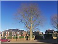
2

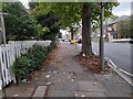
Hendon Avenue at the junction of Dollis Avenue
Image: © David Howard
Taken: 26 Feb 2021
0.06 miles
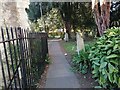

6
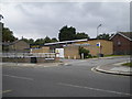
St Mary's Hall, Hendon Lane N3
At the junction with Rectory Close
Image: © Robin Sones
Taken: 29 Aug 2010
0.09 miles
7

Path from Church Crescent to Hendon Lane
Image: © David Howard
Taken: 12 Jun 2021
0.09 miles
8
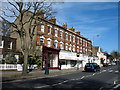
Hendon Lane
Terrace of shops on Hendon Lane seen from the junction with Gravel Hill.
Image: © Martin Addison
Taken: 12 Mar 2007
0.09 miles
10

Ordnance Survey 1GL Bolt
This OS Bolt can be found on the SW face of St Mary's Church. It marks a point 85.789m above mean sea level.
Image: © Adrian Dust
Taken: 2 Aug 2016
0.09 miles