IMAGES TAKEN NEAR TO
Lyndhurst Gardens, LONDON, N3 1TB
Introduction
This page details the photographs taken nearby to Lyndhurst Gardens, N3 1TB by members of the Geograph project.
The Geograph project started in 2005 with the aim of publishing, organising and preserving representative images for every square kilometre of Great Britain, Ireland and the Isle of Man.

There are currently over 7.5m images from over14,400 individuals and you can help contribute to the project by visiting https://www.geograph.org.uk
Image Map
Images are licensed for reuse under creativecommons.org/licenses/by-sa/2.0
Notes
- Clicking on the map will re-center to the selected point.
- The higher the marker number, the further away the image location is from the centre of the postcode.
Image Listing (73 Images Found)
Images are licensed for reuse under creativecommons.org/licenses/by-sa/2.0
Image
Details
Distance
1

Lyndhurst Gardens
A wide suburban street with semi-detached housing.
Image: © Martin Addison
Taken: 29 Jun 2008
0.02 miles
2

Finchley Manor Club
A sports facility on Lyndhurst Gardens providing Tennis, Squash and Gym facilities. There also appears to be a swimming pool.
Image: © Martin Addison
Taken: 29 Jun 2008
0.04 miles
3

Footpath to Dollis Avenue
How do you deal with graffiti? Take any colour external paint you've got handy and paint over it. The result is this patchwork quilt of a fence. This is the Lyndhurst Avenue to Dollis Avenue part of the footpath that leads from Dollis Road. Finchley Manor Club is out of shot on the right.
Image: © Martin Addison
Taken: 29 Jun 2008
0.05 miles
4

Christ's College Sports Ground
The second of two fields divided by the footpath between Dollis Road and Lyndhurst Gardens. In the distance, between the trees, the viaduct carrying the Northern Line across the Dollis Valley to Mill Hill East can be seen.
Image: © Martin Addison
Taken: 29 Jun 2008
0.07 miles
5

Playing fields, Finchley
Private, as may be seen.
Image: © Robin Webster
Taken: 25 Nov 2012
0.08 miles
6

Dollis Avenue
Another wide suburban street with detached housing. A Volvo 4x4 tests its off road capabilities over a speed hump.
Image: © Martin Addison
Taken: 29 Jun 2008
0.10 miles
7

Bridge over Crescent Road
Originally part of the Edgware, Highgate and London Railway, the Northern Line routes through to Mill Hill East from Finchley Central. The line, which originally routed through to Edgware, was always single track but the bridges, as clearly visible from the extended piers here, were constructed wide enough to permit double tracks for future expansion. Unfortunately, the Edgware line fell upon bad times as road transport grew and Underground services were proposed for Edgware in the 1930's. The branch, beyond Mill Hill East, saw limited traffic and was closed to passengers in 1961, but freight services continued until 1964. A current 1995 stock Northern Line train crosses the bridge en-route to Mill Hill East.
Image: © Martin Addison
Taken: 12 Jul 2006
0.10 miles
8

Christ's College Sports Ground
One of two fields on either side of the footpath between Dollis Road and Lyndhurst Gardens.
Image: © Martin Addison
Taken: 29 Jun 2008
0.10 miles
9
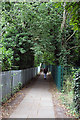
Footpath to Lyndhurst Gardens
This footpath runs from Dollis Road via Lyndhurst Gardens to Dollis Avenue. This section passes between two sports fields belonging to Christ's College.
Image: © Martin Addison
Taken: 29 Jun 2008
0.11 miles
10
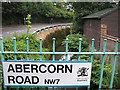
Dollis Brook
Confined by high walls the brook follows the bend of Dollis Road as it passes under Abercorn Road. The road name is in the current style, including borough crest. Someone else is out for their early morning exercise.
Image: © Martin Addison
Taken: 14 Aug 2006
0.12 miles