IMAGES TAKEN NEAR TO
St. Mary's Avenue, LONDON, N3 1SW
Introduction
This page details the photographs taken nearby to St. Mary's Avenue, N3 1SW by members of the Geograph project.
The Geograph project started in 2005 with the aim of publishing, organising and preserving representative images for every square kilometre of Great Britain, Ireland and the Isle of Man.

There are currently over 7.5m images from over14,400 individuals and you can help contribute to the project by visiting https://www.geograph.org.uk
Image Map
Images are licensed for reuse under creativecommons.org/licenses/by-sa/2.0
Notes
- Clicking on the map will re-center to the selected point.
- The higher the marker number, the further away the image location is from the centre of the postcode.
Image Listing (62 Images Found)
Images are licensed for reuse under creativecommons.org/licenses/by-sa/2.0
Image
Details
Distance
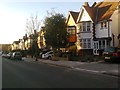
4
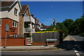
Flats on Hendon Lane at the entrance to Cyprus Avenue
Image: © Christopher Hilton
Taken: 22 May 2017
0.11 miles
5

Hendon Lane at the entrance to Cyprus Avenue
Image: © Christopher Hilton
Taken: 22 May 2017
0.11 miles
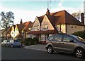
6
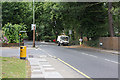
Hendon Lane
Council workers clean away the fallen leaves on Hendon Lane. The road on the left is Cyprus Road, whilst the one on the right behind the Scarab road sweeper is Windsor Road.
Image: © Martin Addison
Taken: 29 Jun 2008
0.12 miles
8

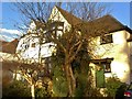
Mock Tudor, Hendon Avenue
Fine examples of the style. Look at those lovely big windows.
Image: © Des Blenkinsopp
Taken: 26 Feb 2019
0.15 miles
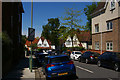
9

Hendon Avenue at the junction of Dollis Avenue
Image: © David Howard
Taken: 26 Feb 2021
0.15 miles