IMAGES TAKEN NEAR TO
Dollis Road, LONDON, N3 1RE
Introduction
This page details the photographs taken nearby to Dollis Road, N3 1RE by members of the Geograph project.
The Geograph project started in 2005 with the aim of publishing, organising and preserving representative images for every square kilometre of Great Britain, Ireland and the Isle of Man.

There are currently over 7.5m images from over14,400 individuals and you can help contribute to the project by visiting https://www.geograph.org.uk
Image Map
Images are licensed for reuse under creativecommons.org/licenses/by-sa/2.0
Notes
- Clicking on the map will re-center to the selected point.
- The higher the marker number, the further away the image location is from the centre of the postcode.
Image Listing (86 Images Found)
Images are licensed for reuse under creativecommons.org/licenses/by-sa/2.0
Image
Details
Distance
1
Dollis Brook
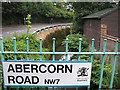
Confined by high walls the brook follows the bend of Dollis Road as it passes under Abercorn Road. The road name is in the current style, including borough crest. Someone else is out for their early morning exercise.
Image: © Martin Addison
Taken: 14 Aug 2006
0.01 miles
3
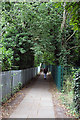
Footpath to Lyndhurst Gardens
This footpath runs from Dollis Road via Lyndhurst Gardens to Dollis Avenue. This section passes between two sports fields belonging to Christ's College.
Image: © Martin Addison
Taken: 29 Jun 2008
0.04 miles
4
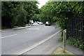
Dollis Road
Dollis Brook passes under the road by the grey railings. Hidden by the trees around the corner in the distance is the viaduct carrying the Mill Hill East branch of the Northern Line across the valley.
Image: © Martin Addison
Taken: 29 Jun 2008
0.05 miles
5
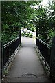
Dollis Valley Green Walk
This bridge carries the walk across Dollis Brook to join Dollis Road. The black and white bollards mark the closed off end of Thornfield Avenue.
Image: © Martin Addison
Taken: 29 Jun 2008
0.05 miles
6

Christ's College Sports Ground
The second of two fields divided by the footpath between Dollis Road and Lyndhurst Gardens. In the distance, between the trees, the viaduct carrying the Northern Line across the Dollis Valley to Mill Hill East can be seen.
Image: © Martin Addison
Taken: 29 Jun 2008
0.05 miles
7

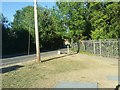
Playing fields, Finchley
Private, as may be seen.
Image: © Robin Webster
Taken: 25 Nov 2012
0.05 miles
8
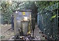
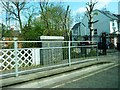
Electricity transformer behind Dollis Road, Finchley
Image: © David Howard
Taken: 31 May 2020
0.06 miles
10
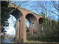
Viaduct over Dollis Road
Impressive structure on the Dollis Valley Greenwalk.
Image: © Peter S
Taken: 10 Mar 2019
0.09 miles