IMAGES TAKEN NEAR TO
Regents Park Road, LONDON, N3 1DP
Introduction
This page details the photographs taken nearby to Regents Park Road, N3 1DP by members of the Geograph project.
The Geograph project started in 2005 with the aim of publishing, organising and preserving representative images for every square kilometre of Great Britain, Ireland and the Isle of Man.

There are currently over 7.5m images from over14,400 individuals and you can help contribute to the project by visiting https://www.geograph.org.uk
Image Map
Images are licensed for reuse under creativecommons.org/licenses/by-sa/2.0
Notes
- Clicking on the map will re-center to the selected point.
- The higher the marker number, the further away the image location is from the centre of the postcode.
Image Listing (398 Images Found)
Images are licensed for reuse under creativecommons.org/licenses/by-sa/2.0
Image
Details
Distance
1
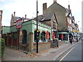
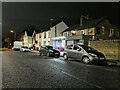
Catcher in the Rye public house
On Regent's Park Road.
Image: © JThomas
Taken: 3 Sep 2016
0.01 miles
2
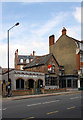
the Catcher in the Rye
A popular public house on Regents Park Road with a variety of ales on tap. The building was a florists and plant nursery when I was a child, sadly I can't remember the name.
Image: © Martin Addison
Taken: 24 Jul 2008
0.01 miles
4
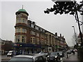
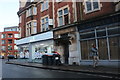
King Edward Hall, Finchley
Built in 1911 as a private banqueting hall, the King Edward Hall became an auxiliary military hospital in 1915, during WW1.It closed as a hospital in 1919. It then returned to being a ballroom where its popularity endured through the 1920s until the late 1930s. During the 1940’s, what was then known as ‘Finchley Council’ moved into the hall when their offices were damaged in the war and the hall was converted into a temporary office for their use. The building was vacated in 1988 and lay unused until 1992 when it was refurbished and renamed as The Regent. It then reopened as a venue for weddings and events.http://www.theregent.org.uk/about-regent
The building was Grade II listed in 2000.The 4-storey corner turret of the building has a clock and a copper dome with a flagstaff.
Image: © Richard Rogerson
Taken: 17 Nov 2015
0.01 miles
8
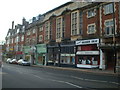
King Edward Hall, Church End, Finchley
Description and link at Image
Image: © Jim Osley
Taken: 17 Nov 2013
0.02 miles
9
King Edward Hall, Finchley: inscription
The midday sun behind the building made it difficult to capture the inscription.
King Edward Hall was built 1911-12 as a private banqueting hall, and served as a VAD hospital during the First World War. It is now a Grade II Listed Building. For more details, see http://www.britishlistedbuildings.co.uk/101380173-king-edward-hall-finchley-church-end-ward#.WaMqKDGos2w .
Image: © Christopher Hilton
Taken: 22 May 2017
0.02 miles
10
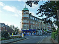
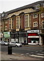
King Edward Hall, Finchley
Occupying the sharp end of the junction between Hendon Lane and Regents Park Road, the hall is above with shops below. A grade II listed building, 1911-12. The clock is wildly wrong.
Image: © Robin Webster
Taken: 25 Nov 2012
0.02 miles