IMAGES TAKEN NEAR TO
Dollis Park, LONDON, N3 1BT
Introduction
This page details the photographs taken nearby to Dollis Park, N3 1BT by members of the Geograph project.
The Geograph project started in 2005 with the aim of publishing, organising and preserving representative images for every square kilometre of Great Britain, Ireland and the Isle of Man.

There are currently over 7.5m images from over14,400 individuals and you can help contribute to the project by visiting https://www.geograph.org.uk
Image Map
Images are licensed for reuse under creativecommons.org/licenses/by-sa/2.0
Notes
- Clicking on the map will re-center to the selected point.
- The higher the marker number, the further away the image location is from the centre of the postcode.
Image Listing (89 Images Found)
Images are licensed for reuse under creativecommons.org/licenses/by-sa/2.0
Image
Details
Distance
1

Bridge over Crescent Road
Originally part of the Edgware, Highgate and London Railway, the Northern Line routes through to Mill Hill East from Finchley Central. The line, which originally routed through to Edgware, was always single track but the bridges, as clearly visible from the extended piers here, were constructed wide enough to permit double tracks for future expansion. Unfortunately, the Edgware line fell upon bad times as road transport grew and Underground services were proposed for Edgware in the 1930's. The branch, beyond Mill Hill East, saw limited traffic and was closed to passengers in 1961, but freight services continued until 1964. A current 1995 stock Northern Line train crosses the bridge en-route to Mill Hill East.
Image: © Martin Addison
Taken: 12 Jul 2006
0.05 miles
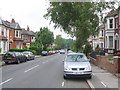
2
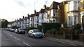
Dollis Road
Dollis Road displays a fine collection of substantial terraced housing.
Image: © Peter Mackenzie
Taken: 11 Sep 2017
0.09 miles
3
Dollis Lane Finchley
Looking SE up the hill towards Ballards Rd and Finchley Central tube station.
Image: © Nigel Mykura
Taken: 2 Jun 2008
0.09 miles
4
The back of houses on Links View from Dollis Road
Image: © David Howard
Taken: 17 Jan 2013
0.09 miles
5

Underground Railway Bridge Finchley
This bridge is between Finchley Central and Mill Hill East on the High Barnet Branch of the Northern Line where Crescent Rd passes under the line.
Image: © Nigel Mykura
Taken: 2 Jun 2008
0.09 miles
6

Mill Hill East Branch
A Northern Line Mill Hill East to Morden via Charing Cross train approaches Finchley Central with car 51665 leading. The train is crossing Crescent Road, one of three bridges in the photo. Further back is Dollis Brook Viaduct and beyond that is the bridge over Frith Lane, just before the line turns left on the approach to its terminus at Mill Hill East. The undulating nature of the track is evident in this telephoto shot - in fact it almost seems like the line sags between the bridges!
Image: © Martin Addison
Taken: 24 Mar 2014
0.10 miles
7

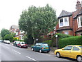
Lyndhurst Gardens
A wide suburban street with semi-detached housing.
Image: © Martin Addison
Taken: 29 Jun 2008
0.10 miles
8

Footpath to Dollis Avenue
How do you deal with graffiti? Take any colour external paint you've got handy and paint over it. The result is this patchwork quilt of a fence. This is the Lyndhurst Avenue to Dollis Avenue part of the footpath that leads from Dollis Road. Finchley Manor Club is out of shot on the right.
Image: © Martin Addison
Taken: 29 Jun 2008
0.10 miles
9
Dollis Lane Finchley
Looking NW down Dollis Lane which is a busy cut through for commuters to and from Finchley.
Image: © Nigel Mykura
Taken: 2 Jun 2008
0.10 miles
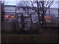
10

Finchley Manor Club
A sports facility on Lyndhurst Gardens providing Tennis, Squash and Gym facilities. There also appears to be a swimming pool.
Image: © Martin Addison
Taken: 29 Jun 2008
0.11 miles