IMAGES TAKEN NEAR TO
Clifton Avenue, LONDON, N3 1BN
Introduction
This page details the photographs taken nearby to Clifton Avenue, N3 1BN by members of the Geograph project.
The Geograph project started in 2005 with the aim of publishing, organising and preserving representative images for every square kilometre of Great Britain, Ireland and the Isle of Man.

There are currently over 7.5m images from over14,400 individuals and you can help contribute to the project by visiting https://www.geograph.org.uk
Image Map
Images are licensed for reuse under creativecommons.org/licenses/by-sa/2.0
Notes
- Clicking on the map will re-center to the selected point.
- The higher the marker number, the further away the image location is from the centre of the postcode.
Image Listing (288 Images Found)
Images are licensed for reuse under creativecommons.org/licenses/by-sa/2.0
Image
Details
Distance
1

Clifton Avenue
Viewed from the junction with Church Crescent.
Image: © Martin Addison
Taken: 29 Jun 2008
0.02 miles

3

Church Crescent
Not so much a crescent as two sides of a distorted square! It had been clouding over off and on all morning and this time I thought I was going to get wet, but within 15 minutes it was clearing again. Nought but a few spots.
Image: © Martin Addison
Taken: 29 Jun 2008
0.05 miles
4

Looking towards Mill Hill
View along the Northern Line Mill Hill East branch. The line becomes single track beyond the siding, although all the structures were built to allow double track should traffic have warranted it. Just beyond the points is the bridge over Crescent Road - the railings are there to stop staff falling from the unused section of the double width bridge piers. A train can be seen disappearing into the distance.
Image: © Martin Addison
Taken: 1 Aug 2006
0.05 miles


7

Finchley: Dollis Park, N3
It seems that the local authority have recently undertaken a regular severe pollarding of the roadside London Plane trees in this area of Finchley, and Dollis Park is no exception. Only open fields were shown in this area on the 1896 Ordnance Survey map, but by the time that the 1913 edition was printed, the current road and house layout was almost completely in place.
Image: © Nigel Cox
Taken: 20 Feb 2011
0.08 miles
8

Path from Church Crescent to Hendon Lane
Image: © David Howard
Taken: 12 Jun 2021
0.10 miles
9
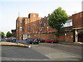
Finchley Telephone Exchange and Sorting Office
Situated on Dollis Park, the tall brick building is the telephone exchange. The sorting office is to the right. The shared site is a direct result of their common heritage as 'Post Office' buildings.
Image: © Martin Addison
Taken: 16 Jun 2006
0.10 miles
10

Path from Church Crescent to Hendon Lane, Finchley
Image: © Robin Webster
Taken: 25 Nov 2012
0.10 miles