IMAGES TAKEN NEAR TO
Baronsmere Road, LONDON, N2 9QG
Introduction
This page details the photographs taken nearby to Baronsmere Road, N2 9QG by members of the Geograph project.
The Geograph project started in 2005 with the aim of publishing, organising and preserving representative images for every square kilometre of Great Britain, Ireland and the Isle of Man.

There are currently over 7.5m images from over14,400 individuals and you can help contribute to the project by visiting https://www.geograph.org.uk
Image Map
Images are licensed for reuse under creativecommons.org/licenses/by-sa/2.0
Notes
- Clicking on the map will re-center to the selected point.
- The higher the marker number, the further away the image location is from the centre of the postcode.
Image Listing (321 Images Found)
Images are licensed for reuse under creativecommons.org/licenses/by-sa/2.0
Image
Details
Distance
1
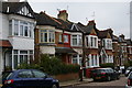
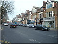
Park Hall Road, East Finchley
Although the houses form a continuous terrace, there is a lot of variety and in fact the terrace is made up of a sequence of semi-detached houses adjacent to each other.
Image: © Christopher Hilton
Taken: 9 Feb 2017
0.04 miles
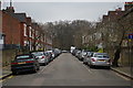
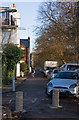
2
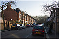
Ingram Road
Seen from the Baronsmere Road end.
Image: © Martin Addison
Taken: 3 Dec 2008
0.04 miles
3
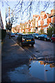
Park Hall Road
Viewed from Brompton Grove.
Image: © Martin Addison
Taken: 3 Dec 2008
0.05 miles
4
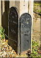
Fortis Green : Borough boundary markers
Boundary of Finchley Boundary Marker (1934) & Borough of Hornsey Boundary Marker No. 316 (1934), Summerlee Gardens, Fortis Green.
Image: © Jim Osley
Taken: 5 Dec 2020
0.07 miles
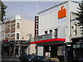
7
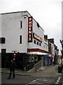
The Phoenix Cinema
Originally the Rex, the cinema was saved from demolition by the Phoenix Trust which celebrated its 21st birthday in December 2006. A wide range of films are shown from arthouse to blockbusters.
Image: © Martin Addison
Taken: 22 Mar 2007
0.08 miles
8
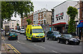
Blues and Twos on the High Road
An ambulance takes to the wrong side of the road to pass a lengthy queue of traffic on its way to a shout. The traffic was particularly heavy this morning (10/06/2009) due to industrial action by the RMT which had closed some underground lines. Ironically, the Northern Line was operating a nearly normal service through East Finchley station just down the hill.
Image: © Martin Addison
Taken: 10 Jun 2009
0.08 miles
9
Phoenix Cinema, High Road N2
At the junction of Fairlawn Avenue
Image: © Robin Sones
Taken: 7 Oct 2010
0.08 miles
10
Brompton Grove
A semi-metalled service road connecting Ingram Road, Park Hall Road and Summerlee Avenue along the boundary of Cherry Tree Woods. The lack of parking restriction on this road in a residents parking zoned area is evident.
Image: © Martin Addison
Taken: 3 Dec 2008
0.08 miles