IMAGES TAKEN NEAR TO
Baronsmere Road, LONDON, N2 9QE
Introduction
This page details the photographs taken nearby to Baronsmere Road, N2 9QE by members of the Geograph project.
The Geograph project started in 2005 with the aim of publishing, organising and preserving representative images for every square kilometre of Great Britain, Ireland and the Isle of Man.

There are currently over 7.5m images from over14,400 individuals and you can help contribute to the project by visiting https://www.geograph.org.uk
Image Map
Images are licensed for reuse under creativecommons.org/licenses/by-sa/2.0
Notes
- Clicking on the map will re-center to the selected point.
- The higher the marker number, the further away the image location is from the centre of the postcode.
Image Listing (321 Images Found)
Images are licensed for reuse under creativecommons.org/licenses/by-sa/2.0
Image
Details
Distance
1
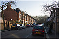
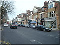
Ingram Road
Seen from the Baronsmere Road end.
Image: © Martin Addison
Taken: 3 Dec 2008
0.02 miles
3
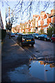
Park Hall Road
Viewed from Brompton Grove.
Image: © Martin Addison
Taken: 3 Dec 2008
0.04 miles
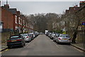
4
Brompton Grove
A semi-metalled service road connecting Ingram Road, Park Hall Road and Summerlee Avenue along the boundary of Cherry Tree Woods. The lack of parking restriction on this road in a residents parking zoned area is evident.
Image: © Martin Addison
Taken: 3 Dec 2008
0.05 miles
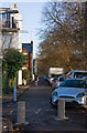
6
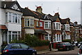
Park Hall Road, East Finchley
Although the houses form a continuous terrace, there is a lot of variety and in fact the terrace is made up of a sequence of semi-detached houses adjacent to each other.
Image: © Christopher Hilton
Taken: 9 Feb 2017
0.06 miles
7
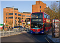
Passing East Finchley Station
A 263 bus heading for Holloway passes the pedestrian crossing by East Finchley Station - the roundel of which is visible behind. The buildings behind are, on the left, McDonald's UK headquarters and, on the right, The Institute. The institute also has buildings behind the station and provides a wide range of adult education courses.
Image: © Martin Addison
Taken: 4 Dec 2009
0.06 miles
8
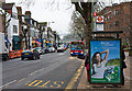
The High Road, East Finchley
Looking down the hill towards East Finchley station. Waiting passengers flag down an approaching 143 bus. Beyond, the bridge carrying the Northern Line over the A1000 can be seen. Although the snow has cleared from the street, leaving behind a layer of grit, it can still be seen lying on Highgate Golf Course in the distance beyond the bridge.
Image: © Martin Addison
Taken: 15 Jan 2010
0.07 miles
9
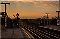
East Finchley Sunrise
A wintery sunrise on East Finchley station. The sheets of cloud on the distant horizon warn of snow later in the day - a case of 'red sky at morning, shepherds warning'. A northbound train waits beyond the bridge over the High Road for a green light to enter the station. Houses on Cherry Tree Hill are also visible beyond the bridge. The sunrise also caught the attention of staff, two of whom joined me in photographing it:-)
It is interesting to compare this shot with Image taken in 2001. Whilst the scene remains the same many of the signs have changed quite a bit.
Image: © Martin Addison
Taken: 16 Dec 2009
0.07 miles
10
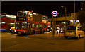
Public Road Transport at East Finchley Station
Buses on the 263 and 102 routes wait in the queue of traffic beside the station while a taxi stands on the forecourt. The traffic jam has been caused by the temporary lights up the hill at the junction of High Road and Fortis Green
Image: © Martin Addison
Taken: 10 Sep 2008
0.08 miles