IMAGES TAKEN NEAR TO
Lauradale Road, LONDON, N2 9LU
Introduction
This page details the photographs taken nearby to Lauradale Road, N2 9LU by members of the Geograph project.
The Geograph project started in 2005 with the aim of publishing, organising and preserving representative images for every square kilometre of Great Britain, Ireland and the Isle of Man.

There are currently over 7.5m images from over14,400 individuals and you can help contribute to the project by visiting https://www.geograph.org.uk
Image Map
Images are licensed for reuse under creativecommons.org/licenses/by-sa/2.0
Notes
- Clicking on the map will re-center to the selected point.
- The higher the marker number, the further away the image location is from the centre of the postcode.
Image Listing (100 Images Found)
Images are licensed for reuse under creativecommons.org/licenses/by-sa/2.0
Image
Details
Distance
6
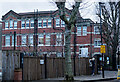
Muswell Hill : Tetherdown Primary School
The image shows the older building of the Tetherdown Primary School site. It dates from 1910 and was built for the Tollington School for Girls to a design by Alfred Conder.
Image: © Jim Osley
Taken: 12 Jan 2021
0.11 miles
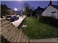
7
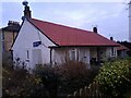
Bungalows on Buckden Close, East Finchley
Image: © David Howard
Taken: 26 Jan 2022
0.11 miles
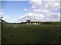
9
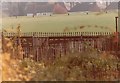
Covered reservoir between Lauradale Road and Woodside Avenue
Image: © David Howard
Taken: Unknown
0.11 miles
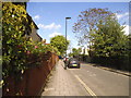
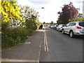
10
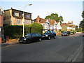
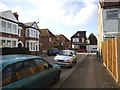
Southern Road
Assorted housing styles along Southern Road.
Image: © Martin Addison
Taken: 13 Jul 2006
0.12 miles