IMAGES TAKEN NEAR TO
Strawberry Vale, LONDON, N2 9AA
Introduction
This page details the photographs taken nearby to Strawberry Vale, N2 9AA by members of the Geograph project.
The Geograph project started in 2005 with the aim of publishing, organising and preserving representative images for every square kilometre of Great Britain, Ireland and the Isle of Man.

There are currently over 7.5m images from over14,400 individuals and you can help contribute to the project by visiting https://www.geograph.org.uk
Image Map
Images are licensed for reuse under creativecommons.org/licenses/by-sa/2.0
Notes
- Clicking on the map will re-center to the selected point.
- The higher the marker number, the further away the image location is from the centre of the postcode.
Image Listing (104 Images Found)
Images are licensed for reuse under creativecommons.org/licenses/by-sa/2.0
Image
Details
Distance
1
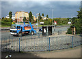
A406 North Circular Road
Westbound bus stop beside the junction with the A1000.
Image: © Martin Addison
Taken: 8 Oct 2007
0.02 miles
2
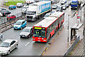
All Snarled Up
On the previous evening a major accident resulted in the closure of the M25 which did not re-open until early-morning resulting in many vehicles diverting inwards onto the North Circular Road (A406). Add to that the road works in the Bounds Green area causing congestion eastbound and an accident at Henlys Corner which temporarily closed the North Circular westbound and you get the car-park effect in this photo. I suspect the upleasantly wet weather isn't helping either :-(
The bendybus in the photo is off route and possibly on one of its last journeys for Arriva in the UK. This vehicle, a Mercedes-Benz Citaro, has been selected for transfer to Arriva Malta where it will replace much older vehicles to the chagrin of transport enthusiasts who have been flocking there over the last few years to photograph them.
Image: © Martin Addison
Taken: 18 Mar 2011
0.03 miles
3
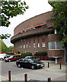
Strawberry Vale
The outer perimeter flats of the Strawberry Vale Estate resemble the curtain walls of a castle.
Image: © Martin Addison
Taken: 8 Oct 2007
0.05 miles
5
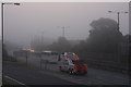
Fog on the A406
A Stansted bound coach and a recovery truck head east. The pink glow in the sky show that the sun has started to burn through the fog. The sign on the left refers to the layout of the junction at the top of the sliproad on the left. Its positioning leaves something to be desired as it could be misread as referring to the North Circular Road itself.
Image: © Martin Addison
Taken: 31 Aug 2008
0.05 miles
6
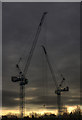
Cranes on a Gloomy day
Tower cranes stand over building works on the site of a scrap merchant's at the end of Lankaster Gardens that is being redeveloped.
Image: © Martin Addison
Taken: 15 Feb 2010
0.06 miles
7
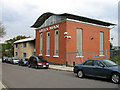
Green Man
Community centre located on the site of the Green Man public house. The centre provides a range of courses, advice and facilities for local people. It also acts as the polling station for elections.
Image: © Martin Addison
Taken: 8 Oct 2007
0.06 miles
8
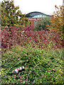
Discarded Can
A discarded lager can rests on the council's easy maintenance shrubs beside the A1000. Behind is the Green Man community centre, named after the public house that used to grace the site. Some of the leaves are changing to their autumn colours.
Image: © Martin Addison
Taken: 8 Oct 2007
0.07 miles
9
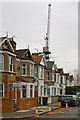
Chambers Gardens
A tower crane looms over the short row of terraced houses on the north side of Chambers Gardens. Behind, a scrap merchant's yard is being re-developed. The cones are in place to prevent cars from parking too close to the corner and restricting access to the site for large lorries.
Image: © Martin Addison
Taken: 15 Feb 2010
0.08 miles
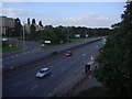
10
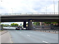
The A406 North Circular Road
This is the North Circular road looking west close to its junction with the A1000 Finchley High Road which passes over on a fly over.
Image: © Nigel Mykura
Taken: 24 Aug 2014
0.08 miles