IMAGES TAKEN NEAR TO
Maddison Terrace, Font Hills, LONDON, N2 8JB
Introduction
This page details the photographs taken nearby to Maddison Terrace, Font Hills, N2 8JB by members of the Geograph project.
The Geograph project started in 2005 with the aim of publishing, organising and preserving representative images for every square kilometre of Great Britain, Ireland and the Isle of Man.

There are currently over 7.5m images from over14,400 individuals and you can help contribute to the project by visiting https://www.geograph.org.uk
Image Map
Images are licensed for reuse under creativecommons.org/licenses/by-sa/2.0
Notes
- Clicking on the map will re-center to the selected point.
- The higher the marker number, the further away the image location is from the centre of the postcode.
Image Listing (173 Images Found)
Images are licensed for reuse under creativecommons.org/licenses/by-sa/2.0
Image
Details
Distance
1

The Lane in Winter
Looking north along Long Lane and across the junction with the A406 North Circular Road. The layout before the A406 became a six-lane dual carriageway is apparent from this winter view. The road on the left is Manor Cottages Approach and the corner house was a grocers shop in the 1960's.
Image: © Martin Addison
Taken: Unknown
0.02 miles
2

Manor Cottages Approach
View of the dogleg end at the junction with Long Lane. The closest Building dates to 1898. I recall the white building was an off-licence and shop in the early 1960's (it wasn't white then). It may have been a public House prior to that.
Image: © Martin Addison
Taken: 12 Jul 2008
0.03 miles
3

Ploughman's Walk, East Finchley
This has all been built since the trunking of the North Circular through Finchley, prior to that this was fields and open land. The other side of the cottages to the south had a field with horses supplying the stables at Strawberry Vale among others. That is now Briar Close while the stables were replaced with a high density council estate.
Image: © David Howard
Taken: 6 Dec 2014
0.03 miles
4
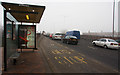
Long Lane Bus Shelter
Extreme wide angle has distorted the shape of the shelter. On a day where the mist lingered until late afternoon, traffic is queuing all the way from Henly's Corner to here because of a single lane closure.
Image: © Martin Addison
Taken: 14 Jan 2009
0.03 miles
5
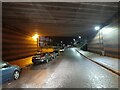
Long Lane going under the North Circular Road
Image: © David Howard
Taken: 10 Feb 2023
0.04 miles
6
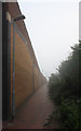
Pedestrian Sliproad
Footpath leading up to the Long Lane bus stop on the west bound North Circular Road.
Image: © Martin Addison
Taken: 31 Aug 2008
0.04 miles
7
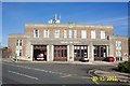
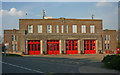
Finchley Fire Station, Long Lane, London N3
The symmetry of the front facade of this fine 1936 built functional municipal building has been spoiled by the addition of the roof plant and masts. Presumably originally built at the junction of Long Lane with the A406 North Circular Road to enable quick access in every direction, the road junction was closed many years ago, and the Fire Station is now at a dead end in Long Lane.
Image: © Nigel Cox
Taken: 30 Oct 2003
0.05 miles
9

North Circular A406
The North Circular before it became a 6 lane dual carriageway. Lots of trees and a bit of a tailback. The bus is Eastern National 1922, a Leyland National. The National Bus company leaf green livery blends in well with the trees!
Image: © Martin Addison
Taken: Unknown
0.05 miles
10

Manor Cottages Approach
The embankment on the right carries the North Circular Road as it climbs to cross the Northern Line, which is hidden behind the vegetation at the end of the road. The sunset marks the end of a pleasant autumn day.
Image: © Martin Addison
Taken: 20 Oct 2007
0.05 miles