IMAGES TAKEN NEAR TO
The Grange, LONDON, N2 8EW
Introduction
This page details the photographs taken nearby to The Grange, N2 8EW by members of the Geograph project.
The Geograph project started in 2005 with the aim of publishing, organising and preserving representative images for every square kilometre of Great Britain, Ireland and the Isle of Man.

There are currently over 7.5m images from over14,400 individuals and you can help contribute to the project by visiting https://www.geograph.org.uk
Image Map
Images are licensed for reuse under creativecommons.org/licenses/by-sa/2.0
Notes
- Clicking on the map will re-center to the selected point.
- The higher the marker number, the further away the image location is from the centre of the postcode.
Image Listing (257 Images Found)
Images are licensed for reuse under creativecommons.org/licenses/by-sa/2.0
Image
Details
Distance
1
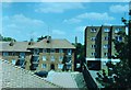
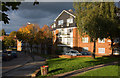
The Grange Estate, East Finchley in summer 1997
Craven House seen from the balcony of 12, Vane House, where I grew up as a child and lived for 20 years, on a warm and sunny day on 27 July 1997. Craven House was one of the first block of flats to be built as part of the new housing estate in 1938. The car park in front was provided in 1993, before that it was a rough tarmac vacant bit of land which had a children's play area on it, and a washing line enclosure. This area was also a bomb site during the Second World War, when Finchley experienced the Blitz in November 1940.
Image: © Alexander Barison
Taken: 27 Jul 1997
0.01 miles
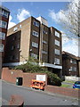
4
Annette White Lodge
Annette White Lodge, 287 High Road, East Finchley N2 8HB. Social Housing for Jewish elderly built in 1977 by Westlon Housing Association Ltd., opened circa April 1978. Photo taken from the kitchen window of 12, Vane House, Grange Estate. This was built on the site of a former Stone Masons, Joslin Memorials, whose offices were located further up the High Road adjacent to Martin Junior School.
Image: © Alexander Barison
Taken: 12 Apr 1997
0.03 miles
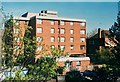
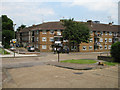
5
The Grange Estate
Vane House on Central Avenue.
Image: © Martin Addison
Taken: 16 Oct 2008
0.04 miles
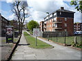
7
Willow House
Representative of housing built on the Grange Estate in the late 1930's to alleviate overcrowding in the area of Market Place and Red Lion Hill. The balconies provide somewhere to sit and to dry washing. There are small areas of grass amongst the concrete slab roads. The children from Bishop Douglas school - centre - are enroute to the bus stops on the High Road (A1000).
Image: © Martin Addison
Taken: 8 Jun 2006
0.04 miles
8
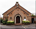
East Finchley : St Mary's Catholic Church
"The church replaced a WW2 damaged church and was built by Westmore and Sanders in collaboration with Mrs G. M. Reeves in 1953." - https://londonchurchbuildings.com/2017/04/21/st-mary-high-road-east-finchley-roman-catholic/. See also this https://taking-stock.org.uk/building/finchley-east-st-mary/.
Image: © Jim Osley
Taken: 20 Dec 2021
0.04 miles
9
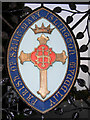
Cemetery gates, East Finchley
This Parish of St Mary Islington crest on the gates to the joint St Pancras Cemetery and Islington Cemetery is one of a pair - the other belonging to the Parish of St Pancras. The cemetery is the largest in London and was first established in 1852.
Image: © Stephen McKay
Taken: 10 Sep 2008
0.04 miles
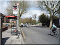
10
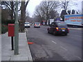
East Finchley High Road
Once the A1, it was bypassed by the new A1 dual carriageway to the west and is now the A1000
Image: © David Howard
Taken: 20 Mar 2013
0.06 miles