IMAGES TAKEN NEAR TO
The Grange, LONDON, N2 8EG
Introduction
This page details the photographs taken nearby to The Grange, N2 8EG by members of the Geograph project.
The Geograph project started in 2005 with the aim of publishing, organising and preserving representative images for every square kilometre of Great Britain, Ireland and the Isle of Man.

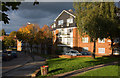
There are currently over 7.5m images from over14,400 individuals and you can help contribute to the project by visiting https://www.geograph.org.uk
Image Map (292 Images)


Getting Data...Please wait
Leaflet Map data © OpenStreetMap
Images are licensed for reuse under creativecommons.org/licenses/by-sa/2.0
Notes
- Clicking on the map will re-center to the selected point.
- The higher the marker number, the further away the image location is from the centre of the postcode.
Image Listing (292 Images Found)
Images are licensed for reuse under creativecommons.org/licenses/by-sa/2.0
Image
Details
Distance
1
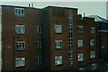
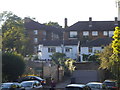
Garden House, Grange Estate in East Finchley
Another view of Garden House from my balcony at 12, Vane House, Central Avenue on the Grange Estate in East Finchley, 4 August 1997
Image: © Alexander Barison
Taken: 4 Aug 1997
0.01 miles
2
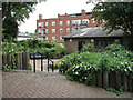
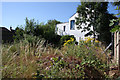
Garden on Grange Estate
Unkempt and uncared for garden area next to the Grange Community Centre. Without the Convolvulus there would be no flowers. It looks like the council have given up on this borough backwater. In the background is one of the blocks of flats, ironically named Garden House, without a tiled roof.
Image: © Martin Addison
Taken: 27 Jun 2006
0.01 miles
3
The Grange Estate
Access road to a parking area.
Image: © Martin Addison
Taken: 18 Sep 2008
0.02 miles
4
Garden House, Grange Estate, East Finchley
Garden House (built circa 1949), Central Avenue on the Grange Estate as seen from my balcony at 12, Vane House on 4 August 1997. In the distance the Red Lion pub can be seen, built circa 1907 on the site of an Inn which originally dated back to 1714 and opened as 'The Rabbit'. It was situated on the corner of Red Lion Hill but unfortunately this lovely example of Edwardian architecture has since been demolished.
Image: © Alexander Barison
Taken: 4 Aug 1997
0.03 miles
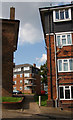
5
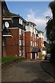
The Grange Estate
Vane House on Central Avenue.
Image: © Martin Addison
Taken: 16 Oct 2008
0.03 miles
6
The Better 'Ole
One time home of the 1st Finchley Scouts. The building was pulled down around 2 years ago after a long period of disuse. The footpath on the right leads from Red Lion Hill to New Trinity Road and Oak lane.
Image: © Martin Addison
Taken: 22 Jul 2008
0.04 miles
7
The Better 'Ole
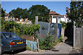
Site of the 1st Finchley Scout hut. The building was demolished around 2 years ago. The white house is the end of terrace on New Trinity Road. The ace colonisers of the plant world have subsequently moved in en-masse. First came the dandelions. Now, the Buddleia, Tansy and Brambles are growing well. Presumably the site will be given over to housing in the future but for now nature rules.
Image: © Martin Addison
Taken: 22 Jul 2008
0.04 miles
9
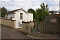
Red Lion Hill
Looking down the footpath that cuts the corner of this road. The dangerous structure referred to on the right is actually the pile of rubble that used to be The Better Ole - the 1st Finchley scout hut. The house on the left was converted from a grocers store in the early 1970's. In the distance on the right is housing on the Grange Estate along King Street.
Image: © Martin Addison
Taken: 21 Aug 2008
0.04 miles
10
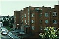
The Grange Estate
Walkway between blocks of flats to Challoner Close
Image: © Martin Addison
Taken: 18 Sep 2008
0.04 miles