IMAGES TAKEN NEAR TO
East End Road, LONDON, N2 8AY
Introduction
This page details the photographs taken nearby to East End Road, N2 8AY by members of the Geograph project.
The Geograph project started in 2005 with the aim of publishing, organising and preserving representative images for every square kilometre of Great Britain, Ireland and the Isle of Man.

There are currently over 7.5m images from over14,400 individuals and you can help contribute to the project by visiting https://www.geograph.org.uk
Image Map
Images are licensed for reuse under creativecommons.org/licenses/by-sa/2.0
Notes
- Clicking on the map will re-center to the selected point.
- The higher the marker number, the further away the image location is from the centre of the postcode.
Image Listing (353 Images Found)
Images are licensed for reuse under creativecommons.org/licenses/by-sa/2.0
Image
Details
Distance
1
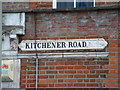
Kitchener road sign
This is probably the "original sign" as it is very ornate and high on the wall.
Image: © Bob Westfield
Taken: 21 May 2006
0.02 miles
2
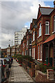
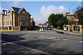
East End Road
A study of the terraced houses along this section of the road. The tower block beyond is on Prospect Ring.
Image: © Martin Addison
Taken: 1 Oct 2008
0.02 miles
3
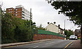
East End Road
View of the bridge carrying the road over the Northern Line. The bridge is quite narrow and bus drivers on the 143 route tend to give way to each other. The tower block on the left is on Prospect Ring.
Image: © Martin Addison
Taken: 25 Aug 2008
0.02 miles
4
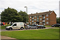
Prospect Ring
Low rise flats on Prospect Ring. There are also two tower blocks.
Image: © Martin Addison
Taken: 21 Aug 2008
0.03 miles
5
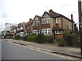
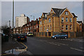
Houses on East End Road, East Finchley
Originally the area between the North Circular and the High Road was called East End, now it's all part of East Finchley.
Image: © David Howard
Taken: 17 Apr 2018
0.03 miles
6
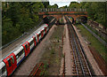
The Northern Line
Looking towards the bridge carrying Prospect Place over the railway to Prospect Ring, from East End Road. The train is bound for High Barnet. Discarded rails litter the areas beside the tracks.
Image: © Martin Addison
Taken: 1 Oct 2008
0.04 miles
10
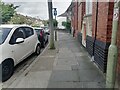
East End Road
Seen from the corner of Deanery Close. The ground is damp from heavy overnight rain, but the day will stay dry until the evening. The terraced houses appeared around 1890, with the exception of the block on the corner of Market Place, on the right. The original corner terrace was demolished and these erected in its place during the 1980's. The flats behind the houses are on Prospect Ring. East End Road turns left in the distance to cross over the Northern Line. Turning right out of Market Place onto East End Road can be difficult as oncoming traffic is masked by parked vehicles.
Image: © Martin Addison
Taken: 5 Feb 2008
0.04 miles